157 results for: Aerial Views
Photograph
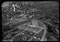
Aerial of Marine Hospital from south, Seattle, April 17, 1933
This view looks northwest over the north tip of Beacon Hill and shows the newly completed Marine Hospital. Designed by John Graham, Sr. in the Art Deco style, the main building was occupied by Amazon from 1998-2010. Handwritten on sleeve: U.S. Marine Hospital 4/17/33.Photographer's number: T-164
ID Number:1983.10.17545.2
Date:1933
Photograph
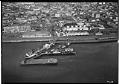
Aerial of Union Oil Co. plant and dock, Seattle, circa 1932
Union Oil Company maintained a large shipping and storage facility along the northern section of Seattle's waterfront. This view looks directly east towards Belltown and shows the many storage tanks that existed at this time between Railroad Avenue and First. Signs in image: Grinnell Company - Automatic Sprinklers, Pipe, Valves, Fittings - Power Piping, Heating & Plumbing Supplies. Union Oil.Handwritten…
ID Number:1983.10.17561.1
Date:Circa 1932
Photograph
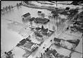
Flood at Orillia, December 12, 1933
Over a week of heavy rains in mid-December 1933 caused mudslides and flooding throughout western Washington state. On December 10, the Seattle Times reported that all area rivers were near flood stage. People from Kelso to Bellingham hoped that continued warm weather wouldn't melt the snow in the mountains and add to the misery.This photo, taken on December 12, 1933…
ID Number:1983.10.17636.9
Date:1933
Photograph
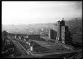
Aerial view of Marine Hospital, Seattle, 1937
The Marine Hospital in Seattle was completed in 1932, and opened in 1933, serving veterans, merchant seamen, the U.S. Coast Guard, U.S. Light House Service, and "federal compensation cases" (the poor and indigent). Now the Pacific Tower, and previously the Pacific Medical Center, the 16-story building is located on Beacon Hill in Seattle, at 1200 12th Avenue South. Designed by…
ID Number:1983.10.17640
Date:1937
Photograph
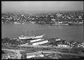
Aerial of Lake Union looking east, Seattle, September 14, 1934
The photographer is taking this view from above Westlake Avenue N. looking towards the east side of Lake Union. The Eastlake neighborhood is visible, with the Montlake Bridge in the distance. Handwritten on sleeve: Diesel Oil Sales Co. 9-14-34.Photographer's Reference Number: T-358
ID Number:1983.10.17641.3
Date:1934
Photograph
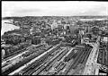
Aerial view of Seattle from south, 1935
This aerial view of downtown Seattle was taken facing north from the present-day location of the SoDo neighborhood. Prominent in the foreground is King Street Station and the rail yard that opened in 1906 to serve both the Great Northern Railway and Northern Pacific Railway, and has served Amtrack since 1971. The waterfront and Elliott Bay are visible on the…
ID Number:1983.10.17697.5
Date:1935
Photograph
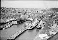
Aerial view of Connecticut Street dock, Seattle, 1935
This aerial view of what is now Seattle's SoDo neighborhood, located just south of downtown, features docks that were owned by the Port of Seattle and utilized by shipping companies. Just north of the docks, at the left center edge of the frame, is what was then Seattle's largest Hooverville, a temporary and improvised shantytown populated by men left unemployed…
ID Number:1983.10.17702.16
Date:1935
Photograph
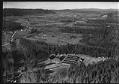
Aerial of Camp Cherry Valley, near Carnation, February 15, 1935
Camp Cherry Valley was a Civilian Conservation Corps (CCC) camp located in the Snoqualmie Valley on land leased from Weyerhaeuser. In 1935, the Washington State Department of Welfare took over the camp and used it as a location to house and feed homeless men in the area. The men were also given jobs constructing public works. During WWII the camp…
ID Number:1983.10.17731.2
Date:1935
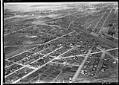
Photograph
Aerial view of Georgetown from the southeast, 1936
Georgetown is located south of downtown Seattle in the Duwamish River Valley. By the time of this 1936 image, much of the river's original course had been filled in for houses, farms, and factories. Empty land created by the filling of the river’s old oxbows can be seen at the left edge of the image, bisected by South Michigan Street…
ID Number:1983.10.17774.1
Date:1936
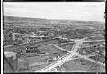
Photograph
Aerial view from the southeast, looking across Georgetown to West Seattle, 1936
Georgetown is located south of downtown Seattle in the Duwamish River Valley. This image shows an area of Beacon Hill, above Georgetown's commercial area and the railroad. Seventeenth Avenue South is partially paved as it heads north, past a large natural gas storage tank and the North Coast Chemical & Soap Works plant. New sidewalks have been built along Seventeenth…
ID Number:1983.10.17774.3
Date:1936