171 results for: Lake Washington Ship Canal
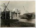
Photograph
Fremont Bridge under construction, Seattle, November 16, 1916
The original bridge to Fremont was razed in 1911 to make way for the dredging of the Lake Washington Canal and temporary bridges were constructed to reroute traffic. This image was taken during construction of the new permanent bridge, which was completed in 1917 and connects Fremont Avenue North on the Fremont side of the Lake Washington Ship Canal and…
ID Number:2006.7.16
Date:1916
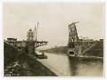
Photograph
Montlake Bridge under construction, Seattle, March 11, 1925
The Montlake Bridge was completed in 1925 and links the Montlake neighborhood and the University District; it is one of four double-leaf bascule bridges that carry vehicle and pedestrian traffic across the Lake Washington Ship Canal, and has been listed on the National Register of Historic Places since 1982. This image of the bridge was taken during construction, and appears…
ID Number:2006.7.24
Date:1925
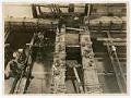
Photograph
Base of University Bridge pier under construction, Seattle, December 10, 1917
The University Bridge was completed in 1919 and connects Eastlake Avenue traffic over Portage Bay between Eastlake to the south and the University District to the north. The bridge is one of four double-leaf bascule bridges that carry vehicle and pedestrian traffic across the Lake Washington Ship Canal, and has been listed on the National Register of Historic Places since…
ID Number:2006.7.32
Date:1917
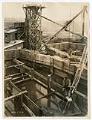
Photograph
University Bridge under construction, Seattle, January 10, 1918
The University Bridge was completed in 1919 and connects Eastlake Avenue traffic over Portage Bay between Eastlake to the south and the University District to the north. The bridge is one of four double-leaf bascule bridges that carry vehicle and pedestrian traffic across the Lake Washington Ship Canal, and has been listed on the National Register of Historic Places since…
ID Number:2006.7.36
Date:1918
Photograph
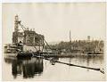
University Bridge piers under construction, Seattle, July 24, 1918
The University Bridge was completed in 1919 and connects Eastlake Avenue traffic over Portage Bay between Eastlake to the south and the University District to the north. The bridge is one of four double-leaf bascule bridges that carry vehicle and pedestrian traffic across the Lake Washington Ship Canal, and has been listed on the National Register of Historic Places since…
ID Number:2006.7.43
Date:1918
Photograph
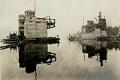
University Bridge under construction, Seattle, October 4, 1918
The University Bridge was completed in 1919 and connects Eastlake Avenue traffic over Portage Bay between Eastlake to the south and the University District to the north. The bridge is one of four double-leaf bascule bridges that carry vehicle and pedestrian traffic across the Lake Washington Ship Canal, and has been listed on the National Register of Historic Places since…
ID Number:2006.7.47
Date:1918
Photograph
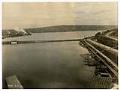
Temporary Stone Way Bridge, Seattle, May 4, 1916
The Stone Way Bridge was a temporary bridge that opened May 31, 1911 over the northwest corner of Lake Union, connecting Westlake Avenue on the south shore to Stone Way on the north. The bridge was in service until June 15, 1917, when the Fremont Bridge, built as part of the Lake Washington Ship Canal project, opened to traffic.This image of…
ID Number:2006.7.50
Date:1916
Photograph
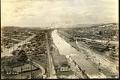
Lake Washington ship canal during construction, Seattle, May 4, 1916
After five and a half years of construction, the Lake Washington Ship Canal opened on May 8, 1917. It connects Lake Washington, Lake Union, Salmon Bay, and Puget Sound. This image looking west from Fremont shows the construction of the Lake Washington ship canal. Prominent in the center of the frame to the right of the canal is the distinctive…
ID Number:2006.7.100
Date:1916
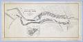
Cartographic material
Proposed Plan and Improvement of Salmon Bay Harbor, Seattle, November 1892
Since the city's earliest days, Seattleites proposed canals to cheaply and easily move logs, coal, and other resources between Elliott Bay and Lake Washington. Possible routes extended from the Black River at the south end of Lake Washington to canals through Lake Union and Shilshole Bay in the north. A 1891 report commissioned by the federal government explored five possible…
ID Number:2008.54.48
Date:1892
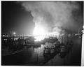
Photograph
Seattle Cedar Lumber Manufacturing Company fire, May 20, 1958
On May 20, 1958, at about 9:25 p.m., a massive fire began that destroyed the Seattle Cedar Lumber Manufacturing Co. at Salmon Bay in Ballard. Fireboats poured water on the flames, the largest fire in Seattle since the fire of 1889. Heat from the fire was felt more than two blocks away, and the fire's glow was visible from Tacoma…
ID Number:2009.23.9
Date:1958