835 results for: Neighborhoods
Photograph
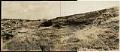
Beacon Hill regrading, Seattle, July 2, 1923
This photograph shows the north end of Beacon Hill facing north. Dearborn Street is visible coming from the left center edge of the frame, between Beacon Hill and what will later be the Chinatown - International District of Seattle. Advertisement billboards visible in the image are for Wrigley's Gum and Wing Foot Tires. This area south of downtown Seattle was…
ID Number:Lib1988.13.7.2.58
Date:1923
Photograph
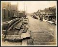
View of 9th Avenue South, Seattle, July 17, 1923
This photograph of 9th Avenue South is looking North, with First Hill in the distance and Beacon Hill on the right. There are two men on the right of the plank road who appear to be at work, another man looks on from the right side of the road. This area south of downtown Seattle was originally made up of…
ID Number:Lib1988.13.7.2.71
Date:1923
Photograph
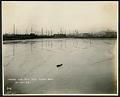
Tidal flats south of downtown Seattle, October 27, 1923
This photograph of the tidal flats taken from south is facing northwest towards the area south of downtown Seattle. Smith Tower is dimly visible in the distance. This area was made up of tidal flats where people and companies were allowed to dig canals and deposit the spoils to make new land. The new buildings, plank roads, and boardwalks were…
ID Number:Lib1988.13.7.2.112
Date:1923
Photograph
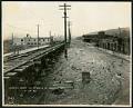
View of 9th Avenue South at Hanford Street, Seattle, October 27, 1923
This photograph of 9th Avenue South at Hanford Street in Seattle was taken facing north, with Beacon Hill visible on the right. This area south of downtown Seattle was originally made up of tidal flats; soil dredged from the Duwamish River and sluiced from the Denny triangle and Beacon Hill regrades was used to create this industrial area needed by…
ID Number:Lib1988.13.7.2.113
Date:1923
Photograph
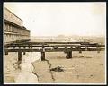
Land fill and tidal flats south of downtown Seattle, November 27, 1923
This photograph shows the land fill and tidal flats of the area south of downtown Seattle. Visible at about the center of the right edge of the frame are men working on a new property by digging canals and deposing the soil to make new land. The building will likely be eventually connected to those around it via plank roads…
ID Number:Lib1988.13.7.2.118
Date:1923
Photograph
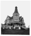
Kinnear home on Queen Anne Hill, circa 1898
George Kinnear arrived in Seattle in 1878 and became active in various civic activities. He promoted road construction through Snoqualmie Pass, organized an immigration board, and was treasurer of a local power and railway company. In 1885, he moved into a large, new mansion the south slope of Queen Anne Hill.This photo, taken by Anders Wilse between 1897 and 1900,…
ID Number:Lib1988.33.42
Date:Circa 1898
Photograph
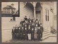
Latona School, Seattle, January 22, 1900
In 1891, a new Latona School building was built in Wallingford. This was the same year that the neighborhood became part of the city of Seattle. The wood-frame school had four large classrooms and four teachers, each paid $900.00 for the year. A new, larger school was built next door in 1906, and the older building was torn down.This photo…
ID Number:Lib1988.33.426
Date:1900
Photograph
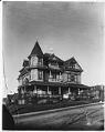
James Nugent residence, Seattle, circa 1898
Captain James Nugent began construction of this home at the corner of Cherry and Twelfth streets in 1892. According to an article published June 6 in the Seattle Post-Intelligencer, the corner tower afforded a fine view of the bay and the Sound and surrounding mountains. There were 14 rooms in all, and the home was supplied with hot water and…
ID Number:Lib1988.33.431
Date:Circa 1898
Photograph
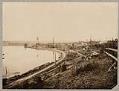
Green Lake Electric Railway tracks along Green Lake, circa 1897
Beginning in 1888, electric streetcar lines were being built in many parts of Seattle. The Green Lake Electric Railway was begun in 1889 to serve the area north of Fremont. The tracks followed an old logging railway route and ran along the eastern shore of Green Lake, ending at about North 70th Street.This late 1890s photo by Anders Wilse shows…
ID Number:Lib1988.33.439
Date:Circa 1897
Photograph
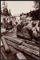
Logs passing through Montlake Ditch, Seattle, circa 1902
The Montlake Cut, between the Montlake and University District neighborhoods in Seattle, connects Lake Washington and Lake Union as part of the Lake Washington Ship Canal. When it was completed in 1916, it marked the realization of a 62-year-old idea to link the lakes with Puget Sound, creating a freshwater harbor in Seattle and a waterway connecting Seattle's shipping harbor…
ID Number:Lib1991.5.12
Date:Circa 1902