835 results for: Neighborhoods
Photograph
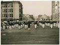
Parade of Naval Training Station personnel, Seattle, circa 1918
During World War I a temporary Naval Training Station was set up on the University of Washington campus, near where the university's health sciences center is now located. The training camp was active from 1917-1919, during which time over 5,000 mostly college students were trained for both naval and naval aviation units.This image of U. S. Navy trainees on parade…
ID Number:Lib1993.35.1.9
Date:Circa 1918
Ephemera
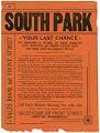
South Park, Your Last Chance to Secure a Home, 1890
The first residents of Seattle's South Park neighborhood, on the west bank of the Duwamish River, were Coast Salish Peoples of the Duwamish Tribe. Beginning in 1851, white settlers like Eli Maple (or Mapel) (1831-1911) staked claims to the land, however the area was mostly utilized by farmers. In 1889, I. William Adams purchased the Donovan farm and he platted…
ID Number:MS.COLL.252
Date:1890
Photograph
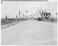
Decorating Ballard Bridge for reopening celebration, Seattle, May 1940
The Ballard Bridge, also known as the 15th Avenue Bridge, is a double-leaf bascule bridge in Seattle which connects Ballard to the Magnolia and Queen Anne neighborhoods. Opened in 1917 and spanning the Lake Washington Ship Canal, the Bridge originally had wooden approaches intended to last only ten years. The bridge was closed for repairs in 1939 and the approaches…
ID Number:PI20464
Date:1940
Photograph
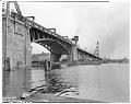
Ballard Bridge crossing Salmon Bay, Seattle, May 1940
The Ballard Bridge, also known as the 15th Avenue Bridge, is a double-leaf bascule bridge in Seattle which connects Ballard to the Magnolia and Queen Anne neighborhoods. Opened in 1917 and spanning the Lake Washington Ship Canal, the Bridge originally had wooden approaches intended to last only ten years. The bridge was closed for repairs in 1939 and the approaches…
ID Number:PI20465
Date:1940
Photograph
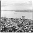
Aerial of Evergreen Point Bridge under construction from southwest, Seattle, 1963
Washington's Evergreen Point Floating Bridge carries State Route 520 across Lake Washington, connecting Seattle with the growing area east of the lake. When it opened, the bridge's 7,578 foot floating span was the longest in the world. This was the second floating bridge to cross Lake Washington, and both bridges are overcrowded daily with commuters in their automobiles.This photo shows…
ID Number:PI20474
Date:1963
Photograph
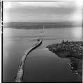
Aerial view of Evergreen Point Floating Bridge, March 1963
Washington's Evergreen Point Floating Bridge carries State Route 520 across Lake Washington, connecting Seattle with the growing area east of the lake. When it opened, the bridge's 7,578 foot floating span was the longest in the world. This was the second floating bridge to cross Lake Washington, and both bridges are overcrowded daily with commuters in their automobiles.//This photo shows…
ID Number:PI20478
Date:1963
Photograph
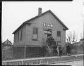
Parishioners exiting Bethany Friends Community Church, Seattle, 1939
Bethany Friends Community Church was located at Atlantic Street and 24th Avenue South in Seattle. It was demolished for the construction of the Lake Washington Floating Bridge. Sign on building reads: Bethany Friends Community Church.Handwritten on image: Lake Wash Bridge expropriates.Handwritten on sleeve: Seattle - churches - Bethany Friends.Date photograph was filed at the Seattle Post-Intelligencer (date of photograph and…
ID Number:PI21247
Date:1939
Photograph
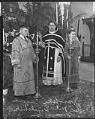
Rev. Michael Danilchik and acolytes, St. Nicholas Russian Orthodox Church, Seattle, 1938
St. Nicholas Russian Orthodox Church was located at 1714 13th Avenue (between Olive and Howell Streets). Reverend Danilchik was the head of the church at this time. The two acolytes are Eugene Ivanofski and George Romanoff. Handwritten on image: Ivanofski, Eugene; Rev. Mike Danilchick [sic]; Romanoff, George.Handwritten on sleeve: Danilchick [sic], Rev. Michael, Seattle (with Geo. Romanoff and Eugene Ivanofski).Date…
ID Number:PI21286
Date:1938
Photograph
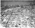
Aerial view of the Central Area after snowstorm, November 22, 1946
This aerial view of the Seattle's Central Area was taken after two days of snow blanketed the city in late November 1946. The view looks west across the Central District, toward Elliiott Bay. At the time, most of Seattle's Black population was concentrated in the Central Area because of housing and job discrimination, and restrictive covenants that prohibited the rental…
ID Number:PI27592
Date:1948
Photograph
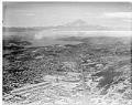
Aerial view of the Rainier Valley after snowstorm, November 22, 1946
This aerial view of the Seattle's Rainier Valley was taken after two days of snow blanketed the city in late November 1946. The view looks southeast towards Mount Rainier, with Rainier Avenue South running upward from the bottom of the frame. Sick's Stadium is visible to the left of Rainier Avenue, in the lower third of the photo.At the time…
ID Number:PI27593
Date:1946