672 results for: Lake Washington
Photograph
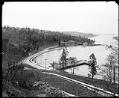
Lake Washington Boulevard at Mount Baker, circa 1913
In 1903, the Olmsted Brothers, a noted firm of New York landscape architects, produced a plan for Seattle's parks. Part of this plan involved a boulevard winding along the western shore of Lake Washington from the university campus to Seward Park.This photo, taken around 1913, shows a stretch of Lake Washington Boulevard at the foot of College Street in the…
ID Number:1983.10.9642
Date:Circa 1913
Photograph
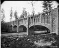
Bridge over Lake Washington Boulevard, Seattle, circa 1914
Located in the Washington Park Arboretum, this historic footbridge was once an aqueduct. Handwritten on sleeve: Interlaken Blvd.Webster & Stevens number: 27044
ID Number:1983.10.9672.1
Date:Circa 1914
Photograph
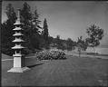
Mount Baker Park, Seattle, circa 1914
Handwritten on sleeve: Mt. Baker Park.Photographer's Reference Number: 36471
ID Number:1983.10.9705
Date:Circa 1914
Photograph
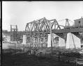
Construction of Great Northern Railway's Ballard Bridge, circa 1913
The Great Northern Railway built a new railway bridge at Ballard in about 1913, during the construction of the Lake Washington Ship Canal. This bridge is still in use in the 2020s, and is known as the Salmon Bay Bridge. The span stays open for canal traffic unless a train is coming.This photo shows the Great Northern Railway bridge during…
ID Number:1983.10.9734.1
Date:Circa 1913
Photograph
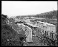
Building the locks at Ballard, circa 1915
Ground was broken for the Lake Washington Ship Canal locks in 1911, and the first concrete was poured for the lock chambers in 1913. This photo, taken between 1913 and 1916, shows the construction of the thick concrete lock walls. Concrete is being moved along the track in huge buckets. Workmen are backfilling the space between the concrete walls and…
ID Number:1983.10.9778
Date:Circa 1915
Photograph
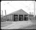
City street car barn, circa 1915
Seattle's electric streetcar system had a number of buildings where the cars could be housed or serviced. These were called streetcar barns. This photo, taken around 1915, shows the Seattle Municipal Railway car barn at Third Avenue North, just south of the the Lake Washington Ship Canal. Webster & Stevens number: 38553
ID Number:1983.10.9804
Date:Circa 1915
Photograph
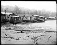
Houseboat damage on Lake Union, 1914
On March 13, 1914, water from Lake Union gushed into the Lake Washington ship canal when a wooden dam in Fremont gave way. The level of the lake dropped approximately ten feet as a result of the accident. Almost 200 houseboat owners suffered losses when the receding waters left their floating homes stranded on the beach or toppled at odd…
ID Number:1983.10.9810.1
Date:1914
Photograph
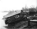
Houseboat damage at Lake Union, Seattle, 1914
On March 13, 1914, water from Lake Union gushed into the Lake Washington ship canal when a wooden dam in Fremont gave way. The level of the lake dropped approximately ten feet as a result of the accident. Almost 200 houseboat owners suffered losses when the receding waters left their floating homes stranded on the beach or toppled at odd…
ID Number:1983.10.9810.2
Date:1914
Photograph
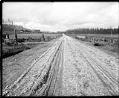
Pacific Highway near Bothell, Washington, 1915
The Pacific Highway ran from Vancouver, British Columbia to southern California, passing through King County, Washington, on the way. Workers completed the stretch of road between Everett and Seattle in 1912. The original route went south through Bothell, turned west to Lake Forest Park and then went south along the shore of Lake Washington to Seattle. The highway was later…
ID Number:1983.10.9946
Date:1915
Photograph
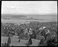
City view and Laurelhurst from Volunteer Park, circa 1915
The water tower in Seattle's Volunteer Park was a favorite place for photographers and others to get good views of the city. This photo, taken around 1915, shows the view to the northeast, over the slope of Capitol Hill to Union Bay and the Laurelhurst peninsula. Kirkland and the Cascade Mountains lie in the distance. Webster & Stevens number: 43511
ID Number:1983.10.9997
Date:Circa 1915