672 results for: Lake Washington
Photograph
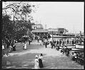
Strolling along the waterfront in Leschi Park, circa 1911
Leschi Park, on the shore of Lake Washington, was a popular place for city-dwellers to go for recreation. Once there, they could catch a boat for a ride on Lake Washington.In this photo, people wander by the landings, get ready to board the boats, or simply sit and talk by the shore. While their clothing may look formal to us…
ID Number:1983.10.8982
Date:Circa 1911
Photograph
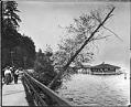
People strolling along waterfront in Leschi Park, Seattle, circa 1910
Leschi Park, on the shore of Lake Washington, was a popular place for Seattle's city-dwellers to go for recreation. Many people caught a cable car at Pioneer Square and rode to the park along Yesler Way. Handwritten on sleeve: Leschi Park.Webster & Stevens number: 17326
ID Number:1983.10.8985
Date:Circa 1910
Photograph
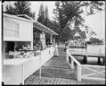
Concessions at Madison Park, circa 1910
Madison Park, at the end of the Madison Street cable car line, was one of Seattle's privately-developed "trolley parks." In addition to a ferry landing, it had a pavilion, a boathouse, picnic areas, piers, a promenade, and offshore bandstands with shoreline seating.This photo shows the concession area at Madison Park in about 1910. On that day, hungry or thirsty visitors…
ID Number:1983.10.8995
Date:Circa 1910
Photograph
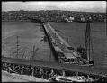
Stone Avenue Bridge under construction, Seattle, circa 1911
Before the Lake Washington Ship Canal was built, a temporary bridge on Stone Avenue carried traffic across to Fremont. Most of the bridge, which opened in 1911, consisted of a wooden roadway on a trestle. The short metal span was just large enough to let logs and small boats pass through. Stone Avenue is now called Stone Way. Handwritten on…
ID Number:1983.10.9146
Date:Circa 1911
Photograph
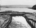
Lake Washington Ship Canal spillway near Fremont, Seattle, circa 1911
During the building of the Lake Washington Ship Canal in Seattle, temporary dams were built at various places to control the water level. This photo shows the spillway of a temporary dam at the western end of Lake Union, near Fremont. Logs for a nearby lumber mill float behind the dam. The Stone Way Bridge is under construction in the…
ID Number:1983.10.9151
Date:Circa 1911
Photograph
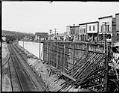
Fremont district, circa 1910
At the start of the twentieth century, Seattle's Fremont area had lumber mills and a commercial district. Before the Lake Washington Ship Canal was built, Fremont's Canal Street ran along a small canal used for moving logs to nearby mills. Railroad tracks ran along the canal.This photo, taken around 1910, shows the building of a retaining wall along Canal Street…
ID Number:1983.10.9152
Date:Circa 1910
Photograph
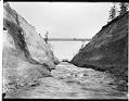
Montlake canal, Seattle, circa 1911
Before the building of the Lake Washington Ship Canal, a small canal connected Lake Washington with Lake Union's Portage Bay. This photo, taken around 1911, shows the canal in the Montlake area and a dam which controlled the water level. Handwritten on sleeve: Lake Wash. Canal.Photographer's Reference Number: 19269
ID Number:1983.10.9158
Date:Circa 1911
Photograph
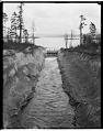
Lake Washington canal at Montlake, circa 1911
Before the building of the Lake Washington Ship Canal, a small canal connected Lake Washington with Lake Union's Portage Bay. This photo, taken around 1911, shows the canal in the Montlake area and a dam which controlled the water level. Webster Point, at Laurelhurst, is in the distant left. Webster & Stevens number: 19272
ID Number:1983.10.9159
Date:Circa 1911
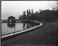
Photograph
Mount Baker boathouse, Seattle, circa 1912
Handwritten on sleeve: Mt. Baker Blvd.Webster & Stevens number: 19761
ID Number:1983.10.9253.2
Date:Circa 1912
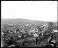
Photograph
Renton city view, circa 1912
The city of Renton is located at the southern shore of Lake Washington, on the site of earlier Coast Salish encampments. Settlers built a sawmill in the area in the 1850s, and coal was discovered nearby in the 1870s. Renton was also an agricultural center. For many years, its primary crop was hops, used in brewing beer.This photo, taken in…
ID Number:1983.10.9436
Date:Circa 1912