171 results for: Lake Washington Ship Canal
Photograph
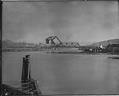
Northern Pacific Railroad bridge, Seattle, circa 1917
This bridge was used by the Northern Pacific railroad to cross the Lake Washington Ship Canal between Fremont and Ballard. Handwritten on sleeve: Bascule Bridge, Lake Wash. canal.Webster & Stevens number: 54405
ID Number:1983.10.10425
Date:Circa 1917
Photograph
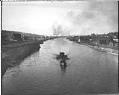
Lake Washington Ship Canal, Seattle, 1917
The Lake Washington Ship Canal followed the routes of earlier canals and streams which connected Lake Washington, Lake Union, and Salmon Bay. This photo shows part of the canal in 1917. It was taken looking west from the Ballard Bridge. Handwritten on sleeve: Ship Canal W. from Ballard Bridge, 1917.Webster & Stevens number: 54408
ID Number:1983.10.10428
Date:1917
Photograph
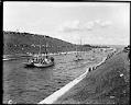
Canal opening, Montlake, July 4, 1917
The Lake Washington Ship Canal opened for business on July 4, 1917, after six years of construction. The opening was the high point of Seattle's Fourth of July celebration. In this photo, spectators crowd the banks of the Montlake Cut to watch the parade of several hundred boats which passed through the new canal. This picture was taken eight years…
ID Number:1983.10.10564
Date:1917
Photograph
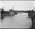
Fremont Bridge on opening day of Lake Washington Ship Canal, Seattle, July 4, 1917
The Lake Washington Ship Canal opened for business on July 4, 1917. The Seattle Times reported that roads, cars, and streetcars heading for the canal were jammed with people wanting to join in the celebration. This photo shows the Fremont Bridge on the afternoon the canal opened. Handwritten on sleeve: Canal Opening Fremont Bridge.Photographer's Reference Number: 59008
ID Number:1983.10.10565
Date:1917
Photograph
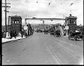
Canal opening, Fremont Bridge, July 4, 1917
The Lake Washington Ship Canal opened for business on July 4, 1917. The Seattle Times reported that roads, cars, and streetcars heading for the canal were jammed with people wanting to join in the celebration. This photo shows the traffic at the south end of the Fremont Bridge on the afternoon the canal opened. Webster & Stevens number: 59009
ID Number:1983.10.10567
Date:1917
Photograph
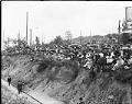
Spectators at opening of Lake Washington Ship Canal, Seattle, July 4, 1917
The Lake Washington Ship Canal opened for business on July 4, 1917, after six years of construction. The opening was the high point of Seattle's Fourth of July celebration. In this photo, spectators crowd the banks of Lake Union to watch the parade of several hundred boats passing through the new canals. It is likely that the photographer was standing…
ID Number:1983.10.10570
Date:1917
Photograph
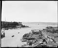
Lake Washington Ship Canal entrance looking west, Seattle, circa 1917
This photo shows the mouth of Salmon Bay after the Lake Washington Ship Canal and the Hiram Chittenden Locks were constructed. The photographer stood on the newly constructed Great Northern Railroad bridge and faced west and slightly south to capture this view of the developing waterfront and the railroad tracks. Handwritten on sleeve: Salmon Bay [sic].Photographer's Reference Number: 59122
ID Number:1983.10.10575
Date:Circa 1917
Photograph
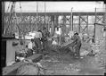
Fishermen checking nets at Fisherman's Terminal, Seattle, circa 1918
For many years, commercial fishermen have kept their boats at Fishermen's Terminal, in Salmon Bay, just west of the Ballard Bridge. This sheltered area of the Lake Washington Ship Canal gives easy access to Puget Sound. In this photo, taken in about 1918, fishermen are checking and mending their gill nets. Handwritten on sleeve: Fisherman's DockWebster & Stevens number: 90660
ID Number:1983.10.10941.2
Date:Circa 1918
Cartographic material
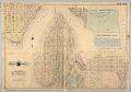
Baist's Real Estate Atlas of Surveys of Seattle, Plate 12, 1908
The G. William Baist Company of Philadelphia produced real estate and insurance maps of over twenty different cities across the United States between the 1880s and 1967. The company published atlases in Seattle in 1905, 1908, and 1912, illustrating property ownership, building materials and improvements, and transportation routes.This map, labeled Plate 12, was separated from the atlas, and shows the…
ID Number:1985.4.13
Date:1908
Photograph
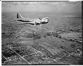
Aerial view of an early Boeing B-17E in flight, Seattle, 1941
The redesigned B-17E differed from previous models in that it included an enlarged tail, more guns and extra armor. It also included a tail gunner position, reducing its vulnerability from the rear. Only about 500 B17Es were built. This view looks northeast from the Magnolia area, showing the Ballard bridge below and Green Lake in the distance. Date photograph was…
ID Number:1986.5.186.1
Date:1941