835 results for: Neighborhoods
Photograph
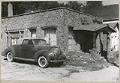
Cobblestone cottage, West Seattle, circa 1940
This pebble-covered home still stands at 1123 Harbor Avenue SW. It is one of several cobblestone cottages built in West Seattle, and possibly dates from the 1920s.
ID Number:SHS7141
Date:Circa 1940
Photograph
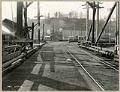
West Spokane Street wooden trestle bridge, Seattle, February 27, 1918
From 1902 to 1917, three temporary wooden bridges were built over the west water way of the Duwamish River, connecting Harbor Island to West Seattle (annexed by Seattle in 1907). By 1924 a permanent steel low-level bascule bridge, West Spokane Street Bridge No. 1 (North), had been built and was in use until 1978.This west-facing view shows one of the…
ID Number:SHS8645
Date:1918
Photograph
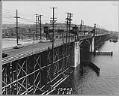
Ballard Bridge, Seattle, July 3, 1938
In 1917, the opening of the first Ballard Bridge over the Lake Washington Ship Canal connected Ballard's business district to downtown Seattle by way of Fifteenth Avenue West and Elliott Avenue. Wooden trestles supported the two-lane roadway, streetcar tracks and sidewalk for most of the bridge's length. After twenty years of increased vehicular traffic and urban growth, the bridge was…
ID Number:SHS8968
Date:1938
Photograph
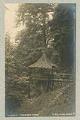
Lookout at Madrona Park, Seattle, 1909
The Madrona beach on Lake Washington was popular for swimming and picnics. In 1890,the park was expanded and an electric trolley line built from downtown Seattle. This image shows a rustic lookout perched on a tree stump in the woods overlooking the shore. SHS category: ParksCaption information source: HistoryLink.org essay 2235.
ID Number:SHS9163
Date:1909
Photograph
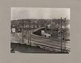
Fremont Bridge from south, Seattle, March 18, 1915
Signs in image: Carl [Dienor?] Groceries. Hay, Grain, Feed & Flour - Wholesale & Retail. [Lundberg?] Lake Union Shop - Horseshoeing & Blacksmithing.Caption on image: 3-18-15.Typed on verso: Fremont Bridge on March 18, 1915, picture taken from Fulton Street and Dexter Avenue North. Photograph was ordered by City Engineering Dept. in preparation for a new bridge. Old bridge was wood…
ID Number:SHS9200
Date:1915
Photograph
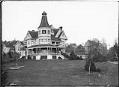
Kinnear residence, Seattle, circa 1900
George Kinnear arrived in Seattle in 1878 and became active in various civic activities. He promoted road construction through Snoqualmie Pass, organized an immigration board, and was treasurer of a local power and railway company. Around 1888, he moved into a large, new mansion the south slope of Queen Anne Hill. This photo shows the Kinnear home on Queen Anne…
ID Number:SHS9652
Date:Circa 1900
Photograph
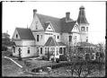
Kinnear residence from rear, Seattle, circa 1900
George Kinnear arrived in Seattle in 1878 and became active in various civic activities. He promoted road construction through Snoqualmie Pass, organized an immigration board, and was treasurer of a local power and railway company. Around 1888, he moved into a large, new mansion the south slope of Queen Anne Hill. This photo shows the Kinnear home on Queen Anne…
ID Number:SHS9654
Date:Circa 1900
Photograph
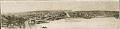
North-facing panorama of Fremont, Seattle, circa 1894
Seattle's Fremont neighborhood started out as cluster of small industries on the north shore of Lake Union. This north-facing view of Fremont appears to have been taken from the eastern slope of Queen Anne Hill. The bridge at the bottom left of the frame is probably a spur of the Seattle, Lake Shore, and Eastern Railway, built in 1888 across…
ID Number:SHS10120
Date:Circa 1894
Photograph
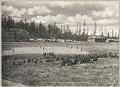
Baseball game at Fort Lawton parade grounds, Seattle, circa 1906
In the first years of the 20th century, baseball was growing in popularity around Seattle. In addition to the city's first professional team, the Seattle Indians, amateur teams popped up across the region, playing at whatever field was available - local parks, the Meadows racetrack, or even the Fort Lawton parade grounds. Teams were organized by neighborhoods, smaller cities around…
ID Number:SHS10366
Date:Circa 1906

Photograph
View of Jackson Street regrade, 1910
Before the Jackson Street regrading project, Beacon Hill formed a barrier between Seattle's waterfront and the Rainier Valley. Between 1907 and 1910, over three million cubic yards of earth were moved to make a cut through the hill. Most of the dirt was used to fill in Seattle's tidal flats.This panorama of the Jackson Street regrade area shows the project…
ID Number:SHS10792
Date:1910