835 results for: Neighborhoods
Photograph
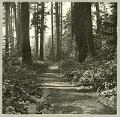
Military road on Beacon Hill, Seattle, circa 1900
The Fort Steilacoom to Fort Bellingham Military Road was a network of roads running through the Puget Sound area to promote the migration of settlers to Washington Territory and to secure U. S. interests in the region from those of Native Americans. Today’s I-5 roughly follows the route north from Fort Vancouver, built in 1924 by the Hudson's Bay Company…
ID Number:SHS2354
Date:Circa 1900
Photograph
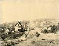
West-facing view of Queen Anne Hill, Seattle, circa 1905
This image of Seattle's Queen Anne Hill neighborhood was taken facing west from Queen Anne Avenue up West Highland Drive. The cable car visible on West Highland Drive is probably part of the northern segment of the Front Street Cable Railway, which ran north along Second Avenue North from the cable car power house at Denny Way, turned west at…
ID Number:SHS3127
Date:Circa 1905
Photograph
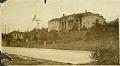
Seattle Children's Home exterior, circa 1915
The Ladies' Relief Society, Seattle's oldest charity, was begun in April 1884 to aid orphaned children. With the donation of two lots from David Denny (1832-1903) and Louisa (Boren) Denny (1827-1916), the society opened their first location, a house at Fourth Avenue and Harrison Street. On April 13, 1905, the society opened a new, larger building on Queen Anne Hill…
ID Number:SHS3763
Date:Circa 1915
Photograph
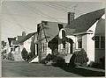
Row of houses in Green Lake area, Seattle, circa 1955
The area near Seattle's Green Lake is filled with small frame houses, many built in the 1920s. This image shows houses on North 76th Street, in the area between Aurora Avenue and Green Lake. Judging by the metal porch railings and the TV antenna, it was likely taken in the 1950s.
ID Number:SHS4259
Date:Circa 1955
Photograph
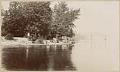
Men and cows at Madison Park, Seattle, August, 1897
The Madison Park neighborhood of Seattle is situated on the western shore of Lake Washington. The Duwamish Peoples who originally inhabited it called it "Where One Chops." After Seattle was founded in the 1850s, the area's first developer, Judge John J. McGilvra (1827-1903), purchased land and opened Madison Street at his own expense in 1864-1865. Madison Park became a favorite…
ID Number:SHS4977
Date:1897
Photograph
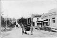
Greenwood Avenue and 85th Street, Seattle, 1904
Signs in image: J.W. Osterhout Groceries. F.B. Mills Cash Grocery. Wholesale and Retail, Hay Grain Feed Wood and Coal.Handwritten on verso: John W. Osterhout, N. 85th, NE corner Greenwood (1909). Mills - 8420 Greenwood Ave.Typed on verso: Greenwood District view north on Greenwood at 85th, 1904.SHS category: Views - Districts
ID Number:SHS5185
Date:1904

Photograph
Police Dept. First and Third Patrol officers posing, Seattle, April 1912
Police departments in metropolitan areas often utilize officers to patrol assigned beats throughout the community. At the time this photograph was taken, the Seattle Police Department had at least three shifts of patrols.This photo shows the uniformed officers of SPD's First and Third Patrol, posing together on the street near C. L. Hazzard's Grocery store at 524 Ninth Avenue, in…
ID Number:SHS5235
Date:1912
Photograph
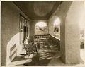
Front porch of the James W. Clemmer home on Capitol Hill, Seattle, circa 1909
James Clemmer and his wife moved to Seattle from Spokane in 1907 and took on the management of his family’s Kenneth Hotel. He soon converted the first floor into the Dream Theater, one of Seattle’s first movie houses. Over the years, Clemmer managed many other Seattle theaters. In 1909, the Clemmers built a Mission Revival home at 2612 Harvard Avenue…
ID Number:SHS5603
Date:Circa 1909
Photograph
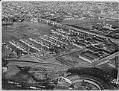
Aerial of Fishermen's Terminal from southwest, Seattle, 1950
For many years, commercial fishermen have kept their boats at Fishermen's Terminal, in Salmon Bay, just west of the Ballard Bridge. This sheltered area of the Lake Washington Ship Canal gives easy access to Puget Sound. Typed on verso: Air view of Salmon Bay Terminal. Largest commercial fishing terminal in U.S., 1950.
ID Number:SHS6172
Date:1950
Photograph
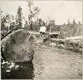
Woman sitting on bridge over Ravenna Creek, Seattle, 1910
Before Green Lake was lowered in 1911 to create the park that surrounds the lake, a stream ran from its eastern shore to Union Bay on Lake Union. The creek, Duke Creek, or more commonly, Ravenna Creek, dried up when Green Lake was lowered. Eventually Ravenna Boulevard was built above the old creek bed with soil dredged from the eastern…
ID Number:SHS6500A
Date:1910