1580 results for: City of Seattle
Photograph
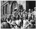
Robert Davis, Jr. leading protest outside SCC, Seattle, May 22, 1969
In 1969, Seattle Community College (SCC) faced boycotts, demonstrations, and rioting in protest of disparities in funding and academic focus between the College's central campus, located near the city's black residential area, and the north and south campuses, located in predominantly white neighborhoods. Out of $33 million in capital funds for the three campuses, the central campus, located on Capitol…
ID Number:2000.107.171.17.01
Date:1969
Photograph
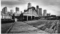
Piers 62 and 63, Seattle, May 23, 1988
Built in 1901 and 1905, respectively, Pier 62 and Pier 63 (originally Pier 10, also Holden Dock, Virginia Dock, or Virginia Street Dock) join together to span nearly two acres on the Seattle waterfront. A thriving ocean terminal before World War II, by the mid-1980s the piers were in disrepair and became part of city plans to revive the central…
ID Number:2000.107.171.34.01
Date:1988
Photograph
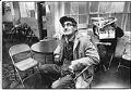
Howard Vail at the First Avenue Service Center, Seattle, December 20, 1979
Seattle's First Avenue Service Center was one of many service organizations seeking to help the homeless and others needing help. Located at 98 Union Street, the Center operated as a daytime drop-in center, with laundry, bathrooms, and shower, and it offered all-night shelter on cold nights. Late in 1979, it was announced that the Center would be evicted due to…
ID Number:2000.107.172.34.04
Date:1979
Photograph
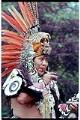
Aztec dancer performing at Folklife Festival, Seattle Center, May 28, 1993
In this image Juan Salinas, leader of Ximali, a group of Aztec dancers from Mexico City, performs during Seattle's annual Northwest Folklife Festival. The festival has been held each Memorial Day weekend since 1972 at Seattle Center as a free celebration of folk and ethnic music, dance, and arts. Caption information derived from captions written by Post-Intelligencer staff.
ID Number:2000.107.172.37.10
Date:1993
Photograph
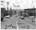
Patrolman handing out Civil Defense evacuation cards, Seattle, May 20, 1955
In this image Robert Vincent, Seattle Police Department patrolman, stands in the center of southbound traffic on Fremont Avenue North to hand out civil defense evacuation cards to motorists. At the time Fremont Avenue was designated a northbound evacuation route for the city. The Fremont Bridge is visible in the background. Signs in image: Salvation Army: Your Throw-Aways Make Work…
ID Number:2000.107.173.03.03
Date:1955
Photograph
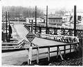
Georgetown's Lucile Street Bridge, Seattle, January 18, 1971
From the west slope of Seattle's Beacon Hill, the Lucile Street Bridge runs under Interstate 5 and over the railroad tracks at the base of the hill, delivering cars, bicycles, and pedestrians onto the streets of the Georgetown neighborhood.This image of the bridge was taken during the period of time in which the City of Seattle and the Burlington Northern…
ID Number:2000.107.173.08.04
Date:1971
Photograph
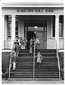
School children at Georgetown Public School, Seattle, January 18, 1971
A school has existed in Seattle's Georgetown neighborhood in one form or another since 1856. The wooden building seen here was built in 1904 to accommodate the burgeoning population of the city. Elementary students were taught in this building until 1971 when the school district built two new schools, Maple Elementary and Dearborn Park. The building was then subleased as…
ID Number:2000.107.173.08.05
Date:1971
Photograph
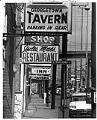
Georgetown taverns on Airport Way South, Seattle, June 1974
Seattle's Georgetown neighborhood was first populated by white settlers in 1851 and existed as an independent city from 1904 to 1910, when it was annexed by Seattle. Home to many breweries, factories, and Boeing Field, the neighborhood became increasingly industrial until a movement in the 1990s pushed for a return to residential facilities. This image taken at South Nebraska Street…
ID Number:2000.107.173.08.06
Date:1974
Photograph
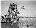
Children playing at Green Lake Swimming Beach, Seattle, circa 1950
One of Seattle's most beloved parks, Green Lake's expanse of water and green space in the center of a dense urban neighborhood draws thousands of people daily from all over the city. The lake was included in the Olmsted Brothers' comprehensive parks plan of 1903, and was given to the City by the State of Washington in 1905. Extensive dredging…
ID Number:2000.107.173.11.01
Date:Circa 1950
Photograph
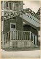
Old Rocking Chair Club, 115 14th Ave. S., Seattle, May 3, 1945
The origin of Seattle's Jazz scene grew out of the unique political and social climate of Prohibition and 1920s and was centered around Jackson Street in what is now the Chinatown - International District neighborhood. A decade later, the beginning of the swing era attracted new listeners to jazz music, particularly young people. The relatively small size of the jazz…
ID Number:2000.107.174.16.01
Date:1945