771 results for: Transportation
Ephemera
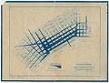
Daily pedestrian traffic map, Seattle, April 1921
The map shown here, created by the Engineers Department, City of Seattle, illustrates average daily pedestrian traffic in the Seattle Downtown Business District for April 1921. The map extends from Blanchard Street to King Street and Railroad Avenue to 8th Street, with a scale running from 2,000 people to 50,000 people taken between 7:00 am and 6:00 pm. Handwritten on…
ID Number:2018.3.8.3
Date:1921
Music, notated
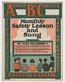
Beware Little Children
The music and lyrics for “Beware Little Children” were written by Charles P. Hughes and published in a pamphlet by F. J. Kroulik in 1925. The pamphlet sought to educate children on safety behaviors around cars and included safety rules as well as a coloring page. One suggestion was for children to have their "teacher form an 'A B C'…
ID Number:2018.3.2.8
Date:1924
Photograph
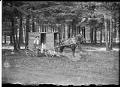
Milkman and wagon at Manitou Park, Tacoma, 1908
In this photo, a young man poses holding a milk can and cup near a horse-drawn milk cart just off a dirt path in a grassy area in Manitou Park in Tacoma. Painted on cart: Jersey Milk
ID Number:2018.48.7
Date:1908
Photograph
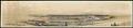
Harbor Island and Beacon Hill, Seattle, 1917
Seattle’s main industrial area, which includes Harbor Island, was built on tidelands at the mouth of the Duwamish River using dirt from the 1907-1909 Jackson Street and other Beacon Hill regrades. In 1911, Fisher Flouring Mills built a large plant on Harbor Island. Shipbuilding and related industries followed. This panoramic photograph, taken from Admiral Way in West Seattle, looks east…
ID Number:2019.3.3
Date:1917
Cartographic material
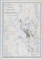
McKee's Correct Road Map of Seattle and Vicinity, 1894
Redick H. McKee (1864-1949) was born in Louisiana and spent his childhood in Washington, D.C. As a young man, Mr. McKee entered the United States Geological Survey (USGS) and was sent to the Sierra Nevadas and other parts of California. In 1892, McKee established the USGS office in Seattle, and remained a resident of the city until his death.The map…
ID Number:2019.3.12
Date:1894
Cartographic material
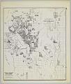
Anderson's New Guide Map of the City of Seattle & Environs, July 1890
Seattle entrepreneur and amateur photographer O. P. (Oliver Phelps) Anderson (1859-1941) was the son of Alexander Jay Anderson (1832-1903), president of the Washington Territorial University (now University of Washington) from 1877-1882. O. P. trained as a drafting technician and by 1890 had started a civil engineering and map publishing business, O. P. Anderson & Company (later O. P. Anderson Map…
ID Number:2019.3.14
Date:1890
Cartographic material
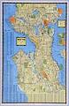
Seattle, Washington, circa 1938
In 1903 Carl Albert Kroll (1882-1982) immigrated from Germany to the U. S., finding work as a drafting technician at the Moran Brothers shipbuilding company. By 1910 Kroll was the manager at O. P. Anderson Map & Blue Print Company. The following year he acquired both the Anderson Map Company and the Washington Map and Blueprint Company to form the…
ID Number:2019.3.18
Date:Circa 1938
Cartographic material
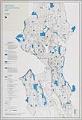
Open Space Proposed Zoning Map, Seattle, December 1985
Since the beginning of the twentieth century, the City of Seattle showed interest in purposefully growing the city. In 1903 the city contracted the Olmsted Brothers to create a comprehensive Seattle park and boulevard system, and in 1910 hired Virgil G. Bogue to prepare a strategic plan. The Seattle Zoning Commission was created in 1920 to divide the city into…
ID Number:2019.3.19
Date:1985

Poster
No Recall, No I-83, No More Delay poster, Seattle, 2004
Interest in expanding Seattle’s 1962 monorail line throughout the city gained momentum with signature-gathering petitions in 1994. In 1997, in spite of almost total opposition by the political establishment, city voters approved Initiative 41 for monorail expansion. Three years later voters approved an additional measure for planning money. Over the next few years, design and funding of the first phase…
ID Number:2019.3.41
Date:2004
Cartographic material
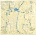
Second Lake Washington Bridge, December 1954
The world's first large-scale floating bridge opened for traffic on July 2, 1940. The concrete roadway from Seattle to the eastern shore of Lake Washington floated on pontoons which were anchored to the lake bottom. The bridge helped the World War II war effort by shortening the commute between Seattle's eastern suburbs and the downtown industrial area, and began suburban…
ID Number:2019.3.43
Date:1954