835 results for: Neighborhoods
Cartographic material
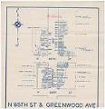
N 85th St & Greenwood Ave map, circa 1935
Born in Wisconsin and raised there and in Walla Walla, Washington, John Davis (1863-1917) moved to Seattle in 1887 where he founded his eponymous real estate brokerage. Following the panic of 1893, Mr. Davis expanded into property management, mortgages, loans, and insurance sales. The company grew steadily into one of the largest real estate corporations on the West Coast, and…
ID Number:2003.9.45
Date:Circa 1935
Cartographic material
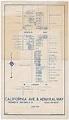
California Ave & Admiral Way map, June 1931
Born in Wisconsin and raised there and in Walla Walla, Washington, John Davis (1863-1917) moved to Seattle in 1887 where he founded his eponymous real estate brokerage. Following the panic of 1893, Mr. Davis expanded into property management, mortgages, loans, and insurance sales. The company grew steadily into one of the largest real estate corporations on the West Coast, and…
ID Number:2003.9.46
Date:1931
Cartographic material
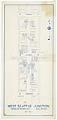
West Seattle Junction map, May 1934
Born in Wisconsin and raised there and in Walla Walla, Washington, John Davis (1863-1917) moved to Seattle in 1887 where he founded his eponymous real estate brokerage. Following the panic of 1893, Mr. Davis expanded into property management, mortgages, loans, and insurance sales. The company grew steadily into one of the largest real estate corporations on the West Coast, and…
ID Number:2003.9.47
Date:1934
Cartographic material
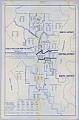
Trend of population growth in Seattle, November 15, 1926
This 1926 map of Seattle is divided into neighborhoods, bounded on the North End by Ballard, and on the South by Rainier Valley and South Park. Each neighborhood is notated with the percentages of city population for that neighborhood for each of five years: 1916, 1920, 1922, 1924 and 1926. The map notes that "the percentages shown are of the…
ID Number:2003.9.48
Date:1926
Photograph
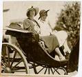
Priscilla Van Sickler and Loyal Nichols at the Olympic Riding and Driving Club, Seattle, 1932
Priscilla Grace Treat (1902-1979) and Loyal Graef Treat (1906-2004) were the daughters of Harry Whitney Treat (1865-1922) and Olive Marion (Graef) Treat (1869-1945). Harry Treat was a real estate developer who established an electric trolley to promote the suburbs of Ballard, Loyal Heights, and Golden Gardens. Harry and Olive were colorful high society figures in Seattle; their Queen Anne mansion…
ID Number:2005.19.3
Date:1932
Photograph
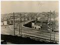
Temporary Fremont Bridge, Seattle, March 18, 1915
The original bridge to Fremont was razed in 1911 to make way for the dredging of the Lake Washington Ship Canal; during this time, all traffic was rerouted to the temporary Stone Way Bridge, just five blocks to the east. A second temporary bridge served the original gap until 1915, when traffic was again rerouted to the Stone Way Bridge…
ID Number:2006.7.1
Date:1915
Photograph
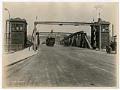
Fremont Bridge on opening day, Seattle, June 15, 1917
The original Fremont Bridge was razed in 1911 to make way for the dredging of the Lake Washington Ship Canal, and a new permanent bridge was constructed to connect Fremont Avenue North in Fremont and Fourth Avenue North in Queen Anne. The new bridge is one of four double-leaf bascule bridges that carry vehicle and pedestrian traffic across the Lake…
ID Number:2006.7.2
Date:1917
Photograph
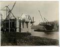
Fremont Bridge under construction, Seattle, November 16, 1916
The original bridge to Fremont was razed in 1911 to make way for the dredging of the Lake Washington Canal and temporary bridges were constructed to reroute traffic. This image was taken during construction of the new permanent bridge, which was completed in 1917 and connects Fremont Avenue North on the Fremont side of the Lake Washington Ship Canal and…
ID Number:2006.7.16
Date:1916
Photograph
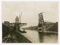
Montlake Bridge under construction, Seattle, March 11, 1925
The Montlake Bridge was completed in 1925 and links the Montlake neighborhood and the University District; it is one of four double-leaf bascule bridges that carry vehicle and pedestrian traffic across the Lake Washington Ship Canal, and has been listed on the National Register of Historic Places since 1982. This image of the bridge was taken during construction, and appears…
ID Number:2006.7.24
Date:1925
Photograph
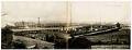
Panorama of West Spokane Street Bridge, Seattle, circa 1924
From 1902 to 1917, three temporary wooden bridges were built over the west water way of the Duwamish River, connecting Harbor Island to West Seattle (annexed in 1907). This panoramic view is facing east, depicting one of the old wooden bridges (right) next to the permanent steel bridge (left) near completion. The new bridge, a low-level bascule bridge, officially known…
ID Number:2006.7.94
Date:Circa 1924