65 results for: Regrades
Photograph
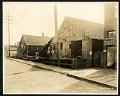
View of Holgate Street and Plum Street intersection at 9th Avenue South, Seattle, May 22, 1923
The image is looking southwest on Holgate Avenue at the Plum Street intersection, from 9th Avenue. This area south of downtown Seattle was originally made up of tidal flats; soil dredged from the Duwamish River and sluiced from the Denny triangle and Beacon Hill regrades was used to create this industrial area needed by area businesses and railroads.This photo is…
ID Number:Lib1988.13.7.2.20
Date:1923
Photograph
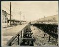
View of 9th Avenue South and Stacy Street, Seattle, May 23, 1923
This photograph looks north on 9th Avenue South and Stacy Street in Seattle. Several wooden buildings belonging to Frye & Company are visible, with large white painted letters reading, "Frye's Delicious Brand Hams & Bacon, Wild Rose Lard." Motorcars line the street as well as horses hitched to delivery wagons. This area south of downtown Seattle was originally made up…
ID Number:Lib1988.13.7.2.29
Date:1923
Photograph
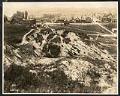
View of Seattle west from Beacon Hill, May 28, 1923
This photograph of the northwest side of Beacon Hill in Seattle is facing west out towards Elliott Bay, which is just visible at the top of the frame. Visible in the image are residential homes as well as many commercial properties and buildings, showing the early development of what would be come an important industrial area of Seattle. This area…
ID Number:Lib1988.13.7.2.33
Date:1923
Photograph
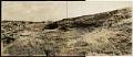
Beacon Hill regrading, Seattle, July 2, 1923
This photograph shows the north end of Beacon Hill facing north. Dearborn Street is visible coming from the left center edge of the frame, between Beacon Hill and what will later be the Chinatown - International District of Seattle. Advertisement billboards visible in the image are for Wrigley's Gum and Wing Foot Tires. This area south of downtown Seattle was…
ID Number:Lib1988.13.7.2.58
Date:1923
Photograph
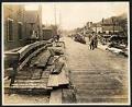
View of 9th Avenue South, Seattle, July 17, 1923
This photograph of 9th Avenue South is looking North, with First Hill in the distance and Beacon Hill on the right. There are two men on the right of the plank road who appear to be at work, another man looks on from the right side of the road. This area south of downtown Seattle was originally made up of…
ID Number:Lib1988.13.7.2.71
Date:1923
Photograph
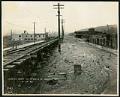
View of 9th Avenue South at Hanford Street, Seattle, October 27, 1923
This photograph of 9th Avenue South at Hanford Street in Seattle was taken facing north, with Beacon Hill visible on the right. This area south of downtown Seattle was originally made up of tidal flats; soil dredged from the Duwamish River and sluiced from the Denny triangle and Beacon Hill regrades was used to create this industrial area needed by…
ID Number:Lib1988.13.7.2.113
Date:1923
Photograph
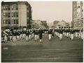
Parade of Naval Training Station personnel, Seattle, circa 1918
During World War I a temporary Naval Training Station was set up on the University of Washington campus, near where the university's health sciences center is now located. The training camp was active from 1917-1919, during which time over 5,000 mostly college students were trained for both naval and naval aviation units.This image of U. S. Navy trainees on parade…
ID Number:Lib1993.35.1.9
Date:Circa 1918
Photograph
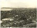
Waterfront from Beacon Hill, Seattle, circa 1898
The area south of downtown Seattle was originally made up of tidal flats; soil dredged from the Duwamish River and sluiced from the Denny triangle and Beacon Hill regrades was used to create this industrial area needed by area businesses and railroads. This image, taken between 1890-1900, shows what much of Seattle's waterfront looked like before the tidal flats were…
ID Number:SHS462
Date:Circa 1898
Photograph
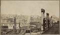
Jackson Street looking east from waterfront, Seattle, circa 1892
The topography of Seattle neighborhood now called the Chinatown - International District (CID) was altered drastically during the Jackson Street regrade from 1907 to 1909. About fifty-six city blocks were reshaped by the regrade, twenty-nine of them excavated and twenty-seven raised above the tide flats. On Jackson, dirt was mostly removed to lower the street nearly 90 feet at 9th…
ID Number:SHS469
Date:Circa 1892
Photograph
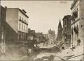
Regrading on Third Avenue near Spring Street, Seattle, 1906
Seattle's hills are steep, but they used to be steeper. During various regrading projects, the city tried to make the streets and avenues more level. Some areas were raised and some were lowered. Nearby buildings were raised or lowered too. Others were torn down or moved away.This photograph was taken during the regrading project on Third Avenue in downtown Seattle.…
ID Number:SHS503
Date:1906