81 results for: Vallentyne, John
Photograph
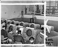
Staff at work at Fort Lawton, Seattle, January 21, 1960
In 1897, the city of Seattle donated land on Magnolia Bluff to the US government to build a new Army post as part of a defense system for Puget Sound; this was designated as Fort Lawton in 1900. During most of its active service, the fort served as an embarkation station where troops gathered before being sent to duty in…
ID Number:2000.107.216.25.03
Date:1960
Photograph
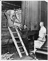
Wine brokers unloading grapes from train, Seattle, September 25, 1963
Wine grapes and apples were among the first cultivated fruits in the Pacific Northwest. Initially planted here in 1827, both were cherished by early pioneering settlers, but whereas apples became a lucrative farm commodity early on, Washington-grown grapes and the local wine industry did not achieve widespread recognition until the 1970s. According to the Washington State Wine organization, as of…
ID Number:2000.107.232.03.04
Date:1963
Photograph
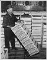
Wine broker unloading grapes from train, Seattle, September 25, 1963
Wine grapes and apples were among the first cultivated fruits in the Pacific Northwest. Initially planted here in 1827, both were cherished by early pioneering settlers, but whereas apples became a lucrative farm commodity early on, Washington-grown grapes and the local wine industry did not achieve widespread recognition until the 1970s. According to the Washington State Wine organization, as of…
ID Number:2000.107.232.03.05
Date:1963
Photograph
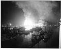
Seattle Cedar Lumber Manufacturing Company fire, May 20, 1958
On May 20, 1958, at about 9:25 p.m., a massive fire began that destroyed the Seattle Cedar Lumber Manufacturing Co. at Salmon Bay in Ballard. Fireboats poured water on the flames, the largest fire in Seattle since the fire of 1889. Heat from the fire was felt more than two blocks away, and the fire's glow was visible from Tacoma…
ID Number:2009.23.9
Date:1958
Photograph
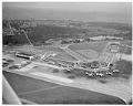
Aerial view of Seattle-Tacoma International Airport, March 7, 1959
On March 7, 1942, three months after Japan attacked Pearl Harbor, the Port of Seattle undertook development of Seattle-Tacoma International Airport at the urging of the federal government. A new airport was desperately needed to help relieve pressure on Seattle’s Boeing Field and Tacoma’s McChord Field, which were commandeered for warplane production and military use in World War II. Sea-Tac’s…
ID Number:2009.23.21
Date:1959
Photograph
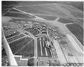
Aerial view of Seattle-Tacoma International Airport, May 8, 1959
On March 7, 1942, three months after Japan attacked Pearl Harbor, the Port of Seattle undertook development of Seattle-Tacoma International Airport at the urging of the federal government. A new airport was desperately needed to help relieve pressure on Seattle’s Boeing Field and Tacoma’s McChord Field, which were commandeered for warplane production and military use in World War II. Sea-Tac’s…
ID Number:2009.23.23
Date:1959
Photograph
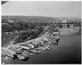
Aerial view of Aurora Bridge over Lake Union, Seattle, April 1960
The Aurora Bridge (officially the George Washington Memorial Bridge) is a cantilever and truss bridge that carries State Route 99 (Aurora Avenue North) over the west end of Seattle's Lake Union. Construction on the bridge piers began in 1929, and the bridge was opened to traffic on February 22, 1932, George Washington's 200th birthday. It was listed on the National…
ID Number:2009.23.31
Date:1960
Photograph
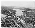
Aerial view of Freeway Bridge during Interstate 5 construction, Seattle, January 1961
Interstate 5 (I-5) is the main Interstate Highway on the West Coast of the United States, and Seattle's widest freeway. The section of I-5 connecting Kent to Seattle to Everett was built between 1960-1966, including "Freeway Bridge," shown in this aerial photograph taken in 1961. The direction of the photograph is looking south and slightly west over Lake Union towards…
ID Number:2009.23.57
Date:1961
Photograph
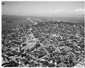
Aerial view of Interstate 5 construction at Denny Way, looking north, January 1961
Interstate 5 (I-5) is the main Interstate Highway on the West Coast of the United States, and Seattle's and widest freeway. The section of I-5 connecting Kent to Seattle to Everett was built between 1960-1966, including the section shown in this aerial photograph taken in 1961. The direction of the photograph is looking north, Lake Union is on the left…
ID Number:2009.23.64
Date:1961
Photograph
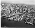
Aerial view of Seattle waterfront, showing Polynesian Restaurant on Pier 51, October 13, 1961
This aerial photograph of the Seattle waterfront features the Polynesian Restaurant, built at the end of Pier 51 (third from right in this photo). The restaurant was completed in June 1961, in time for the following year’s infusion of tourists for the Century 21 World’s Fair. The Polynesian was Seattle’s grandest example of Tiki décor, but was torn down in…
ID Number:2009.23.74
Date:1961