389 results for: A. D.
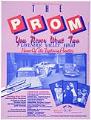
Poster
The Prom You Never Went To poster, Seattle, May 27, 1984
The nonprofit Tacky Tourist Clubs of America was founded in Seattle in the early 1980s, and incorporated in 1988. The organization sponsored annual parties and events to raise money for other nonprofits, mostly those benefiting the gay and lesbian community. Three popular annual events were the Queen City Cruise, an "unofficial Seafair" event on Elliott Bay and beloved by many;…
ID Number:2007.9.25
Date:1984
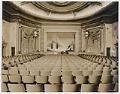
Photograph
Interior of Bagdad Theatre, Seattle, circa 1927
Seattle's Bagdad Theatre operated from 1927-1947 at one of the Ballard neighborhood's most significant buildings, located on the northwest corner of Market Street and 22nd Avenue NW. The building was designed by local architect Frederick J. Peters as the home of the Ballard chapter of the Fraternal Order of Eagles (F.O.E.), an international non-profit organization founded in 1898 in Seattle.…
ID Number:2008.47.2
Date:Circa 1927
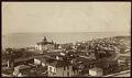
Photograph
View from First Hill toward Elliott Bay, Seattle, circa 1885
This view from First Hill looking west and north toward Elliott Bay was taken before the Great Seattle Fire in 1889. The large white building in the center of the frame is the Central School, built in 1883 at Sixth Avenue and Madison Street, and destroyed in an 1888 fire; just behind and to the right of Central School is…
ID Number:2008.54.16
Date:Circa 1885
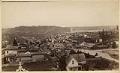
Photograph
View looking north toward Queen Anne Hill, Seattle, circa 1885
This image of the city was taken from the roof of Central School, and is facing north, with Seventh Avenue on the right, and Queen Anne Hill straight ahead. Smoke can be seen rising from Western Mill on Lake Union in the distance. On June 6, 1889, the Great Seattle Fire destroyed 25 city blocks, including much of what is…
ID Number:2008.54.17
Date:Circa 1885
Photograph
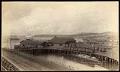
King Street Coal Works dock on Elliott Bay, Seattle, circa 1885
This view of Elliott Bay is facing north and west. Seen here are two full-rigged-ships sitting in Elliott Bay; the King Street Coal Works at Second Avenue and Columbia Street, with the C&PSRR Co. (Columbia & Puget Sound Rail Road) Ocean Dock and Norther Pacific rail cars; and the edges of Ballast Island at the foot of Washington Street and…
ID Number:2008.54.23
Date:Circa 1885
Photograph
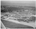
Aerial view of Seattle-Tacoma International Airport, March 7, 1959
On March 7, 1942, three months after Japan attacked Pearl Harbor, the Port of Seattle undertook development of Seattle-Tacoma International Airport at the urging of the federal government. A new airport was desperately needed to help relieve pressure on Seattle’s Boeing Field and Tacoma’s McChord Field, which were commandeered for warplane production and military use in World War II. Sea-Tac’s…
ID Number:2009.23.21
Date:1959
Photograph
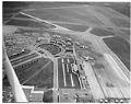
Aerial view of Seattle-Tacoma International Airport, May 8, 1959
On March 7, 1942, three months after Japan attacked Pearl Harbor, the Port of Seattle undertook development of Seattle-Tacoma International Airport at the urging of the federal government. A new airport was desperately needed to help relieve pressure on Seattle’s Boeing Field and Tacoma’s McChord Field, which were commandeered for warplane production and military use in World War II. Sea-Tac’s…
ID Number:2009.23.23
Date:1959
Photograph
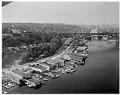
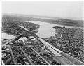
Aerial view of Aurora Bridge over Lake Union, Seattle, April 1960
The Aurora Bridge (officially the George Washington Memorial Bridge) is a cantilever and truss bridge that carries State Route 99 (Aurora Avenue North) over the west end of Seattle's Lake Union. Construction on the bridge piers began in 1929, and the bridge was opened to traffic on February 22, 1932, George Washington's 200th birthday. It was listed on the National…
ID Number:2009.23.31
Date:1960
Photograph
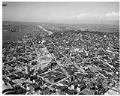
Aerial view of Freeway Bridge during Interstate 5 construction, Seattle, January 1961
Interstate 5 (I-5) is the main Interstate Highway on the West Coast of the United States, and Seattle's widest freeway. The section of I-5 connecting Kent to Seattle to Everett was built between 1960-1966, including "Freeway Bridge," shown in this aerial photograph taken in 1961. The direction of the photograph is looking south and slightly west over Lake Union towards…
ID Number:2009.23.57
Date:1961
Photograph
Aerial view of Interstate 5 construction at Denny Way, looking north, January 1961
Interstate 5 (I-5) is the main Interstate Highway on the West Coast of the United States, and Seattle's and widest freeway. The section of I-5 connecting Kent to Seattle to Everett was built between 1960-1966, including the section shown in this aerial photograph taken in 1961. The direction of the photograph is looking north, Lake Union is on the left…
ID Number:2009.23.64
Date:1961