182 results for: Curtis
Photograph
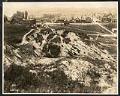
View of Seattle west from Beacon Hill, May 28, 1923
This photograph of the northwest side of Beacon Hill in Seattle is facing west out towards Elliott Bay, which is just visible at the top of the frame. Visible in the image are residential homes as well as many commercial properties and buildings, showing the early development of what would be come an important industrial area of Seattle. This area…
ID Number:Lib1988.13.7.2.33
Date:1923
Photograph
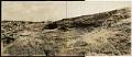
Beacon Hill regrading, Seattle, July 2, 1923
This photograph shows the north end of Beacon Hill facing north. Dearborn Street is visible coming from the left center edge of the frame, between Beacon Hill and what will later be the Chinatown - International District of Seattle. Advertisement billboards visible in the image are for Wrigley's Gum and Wing Foot Tires. This area south of downtown Seattle was…
ID Number:Lib1988.13.7.2.58
Date:1923
Photograph
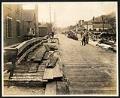
View of 9th Avenue South, Seattle, July 17, 1923
This photograph of 9th Avenue South is looking North, with First Hill in the distance and Beacon Hill on the right. There are two men on the right of the plank road who appear to be at work, another man looks on from the right side of the road. This area south of downtown Seattle was originally made up of…
ID Number:Lib1988.13.7.2.71
Date:1923
Photograph
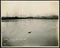
Tidal flats south of downtown Seattle, October 27, 1923
This photograph of the tidal flats taken from south is facing northwest towards the area south of downtown Seattle. Smith Tower is dimly visible in the distance. This area was made up of tidal flats where people and companies were allowed to dig canals and deposit the spoils to make new land. The new buildings, plank roads, and boardwalks were…
ID Number:Lib1988.13.7.2.112
Date:1923
Photograph
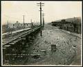
View of 9th Avenue South at Hanford Street, Seattle, October 27, 1923
This photograph of 9th Avenue South at Hanford Street in Seattle was taken facing north, with Beacon Hill visible on the right. This area south of downtown Seattle was originally made up of tidal flats; soil dredged from the Duwamish River and sluiced from the Denny triangle and Beacon Hill regrades was used to create this industrial area needed by…
ID Number:Lib1988.13.7.2.113
Date:1923
Photograph
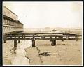
Land fill and tidal flats south of downtown Seattle, November 27, 1923
This photograph shows the land fill and tidal flats of the area south of downtown Seattle. Visible at about the center of the right edge of the frame are men working on a new property by digging canals and deposing the soil to make new land. The building will likely be eventually connected to those around it via plank roads…
ID Number:Lib1988.13.7.2.118
Date:1923
Photograph
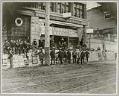
Miners and supplies outside Cooper & Levy, circa 1897
After news of Klondike gold reached Seattle in July 1897, many of Seattle's stores joined the excitement and became gold rush outfitters. Cooper & Levy, just south of Pioneer Square, provided gold seekers with crates and sacks of flour, bacon, dried fruit, condensed milk, tea, soap, matches, and many other items needed for life in the north.This 1897 photo shows…
ID Number:SHS401
Date:Circa 1897
Photograph
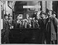
Alaskan gold at the Scandinavian American Bank, circa 1901
Between 1897 and 1910, gold and money from the gold rush poured into Seattle's banks. Between May 1897 and September 1903, deposits at Seattle's Scandinavian American Bank grew from $170,594.08 to nearly $2.7 million.This photo was taken sometime between 1897 and 1902, at the Scandinavian American Bank in Seattle. It shows bank president Andrew Chilberg (right, behind counter) and a…
ID Number:SHS404
Date:circa 1901
Photograph
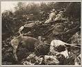
Dead horses on White Pass Trail, 1898
In 1897 and 1898, many of the Klondike stampeders used pack horses and mules to carry supplies along the White Pass Trail. Smart pack train owners took good care of their animals, but the trail was rough and the work was extremely hard. There was no feed in the mountain canyons and no water in winter. Animals who were too…
ID Number:SHS411
Date:1897
Photograph
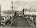
First Ave. South from King Street, Seattle, circa 1900
This view of First Avenue South looks north from King Street and was possibly taken from the railroad trestle that crossed First Avenue at King until 1903. Arctic Oil Works at 313 First Avenue South and Jackson is visible at left. In this image, pedestrians walk on the plank sidewalks and the 1st Avenue trolley heads south in the middle…
ID Number:SHS958
Date:Circa 1900