Seattle’s waterfront is changing. Most recently, the area that was once the Alaskan Way Viaduct was redeveloped into a park promenade and bike path—but this is only one major transformation in its storied past. Explore some of the history of Seattle’s waterfront through images in the MOHAI collection below.
/ April 30, 2025
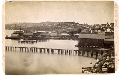
Waterfront from near Yesler's wharf, circa 1882
MOHAI, SHS3506
What we now know as Seattle’s waterfront had been a fishing village and trading hub for Coast Salish Peoples and visiting tribes since time immemorial. The area was called Dzidzilalich or “Little Crossing-Over” place in Lushootseed.
European settlers moved from Alki to the Seattle waterfront area in 1852. The Treaty of Point Elliot, signed in 1855, forcibly removed the Duwamish and Suquamish Peoples from Dzidzilalich and kickstarted the first major transformation of the land under settler control. Within a few decades the waterfront had been cleared, and the city of Seattle began to grow around it. This image, taken around 1882, shows the waterfront area at the time it was home to industries like logging and shipping and residential buildings for the city’s burgeoning population.
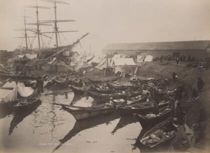
Native American camp with canoes, Ballast Island, Washington Street, circa 1890
MOHAI, David Thomas Denny II Family Papers, 2011.26.7.43
In 1865 the Board of Trustees of Seattle passed Ordinance No. 5, which banned Indigenous peoples from living in the city unless they worked for a non-Indigenous resident and lived on their employer’s property. However, settlers continued to rely on Native peoples for domestic work and for the trade of fish, shellfish, and baskets. Indigenous peoples continued to come through the Seattle waterfront from across the Pacific Northwest for this trade and as a stopping point on their way to harvest hops in agricultural areas to the south and east of Seattle.
As a result, many Indigenous peoples stayed on Ballast Island, either when passing through or to live on the island year-round. Ballast Island was in the harbor at the foot of Washington Street. It was created when sailing ships dumped their ballast in Elliott Bay to take on cargo. As the waterfront continued to grow throughout the 1890s, Ballast Island was gradually covered with landfill. By the time the seawall was built in 1916, the island was almost completely gone, displacing yet again the Indigenous people who lived there.
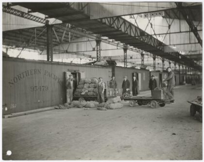
Employees inside Admiral Line terminal at Pier D, Seattle, 1925
MOHAI, 1970.4892.3
In the early twentieth century, the waterfront grew rapidly as maritime trade with global partners expanded. One of these companies, the Pacific Coast Steamship Company, was an important early shipping company that operated steamships on the west coast of North America. The Admiral Line (also American Mail Line, and later Admiral Oriental Line) was based in Seattle and operated five ocean liners sailing from Seattle to Japan and China. The Admiral Line also adopted the name “The Pacific Steamship Company,” which it used until 1936 when operations ceased. This photo shows employees at the Admiral Line terminal on Pier D at 1519 Railroad Avenue South.
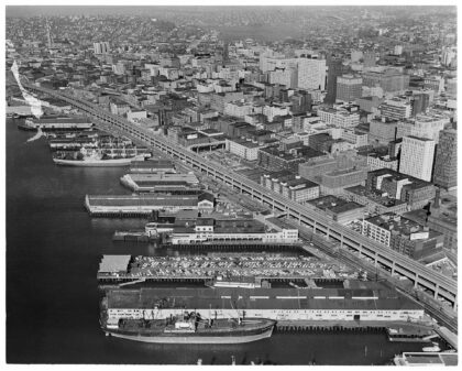
Aerial view of Seattle waterfront, including viaduct construction, 1961
MOHAI, John Vallentyne Collection, 2009.23.77
By the mid-twentieth century, the waterfront was a working waterfront, separated from downtown Seattle by the important thoroughfare of the Alaskan Way Viaduct. This aerial photograph from 1961 features the viaduct nearing completion after what would be 16 years of construction (1950-1966). The viaduct was part of a larger effort to develop the remaining two-lane segments of State Route 99, also known as Pacific Highway, into a four-lane roadway from the Oregon border to the Canadian border. The piers along Seattle’s waterfront also feature prominently in this photograph, as does the construction of the Space Needle in the upper left corner of the frame.
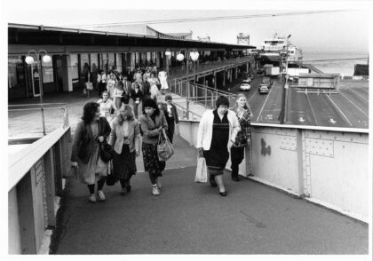
Ferry commuters arriving in Seattle, September 23, 1983
MOHAI, Washington Day Shoot Collection, 1984.118.001, photo by Ned Ahrens
Throughout this time, locals regularly travelled along the waterfront and Colman Dock (or Pier 52). Before the introduction of regular ferry service, hundreds of small steamers competed to carry people and freight around Puget Sound. There were so many of these vessels making short runs between so many towns and islands that they were called the Mosquito Fleet. In 1951, Washington state took over the ferries and built a new terminal ten years later. In this photo from 1983, ferry commuters, likely from Bainbridge or Bremerton, leave the terminal at Colman Dock.
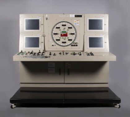
Central control panel from "Bertha," the Seattle Tunnel Boring Machine, ca. 2012
MOHAI, 2017.42.1.1. Gift of Hitachi Zosen USA Ltd.
Several sections of the Alaska Way Viaduct were damaged in February 2001 during the Nisqually earthquake. In 2009, state, county and city officials agreed to replace the viaduct by boring a two-mile long tunnel under the city’s waterfront.
Pictured here is the control panel from the Seattle Tunnel Boring Machine (TBM), nicknamed “Bertha” after Seattle’s first female mayor Bertha Knight Landes. It was the largest TBM ever built at the time in 2012. The control panel was the heart of the machine where the operators controlled the intricate mechanisms of the 57-foot diameter cutter head.