280 results for: Lake Union
Photograph
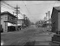
Fremont Avenue looking north, Seattle, circa 1907
Seattle's Fremont neighborhood, northwest of Lake Union, was named after a town in Nebraska where some of its early promoters hailed from. Fremont started in the 1880s as a settlement around a sawmill, and grew to a town of 5,000 before it became part of Seattle in 1891. Signs in image: Mabel E. Canney - Piano. [...] Laundry. Fremont Drug…
ID Number:1983.10.7777
Date:Circa 1907
Photograph
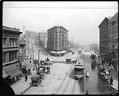
The intersection of Fourth and Westlake Avenues, circa 1909
In the early 1900s, Westlake Avenue ran from Lake Union through what is now Westlake Park in downtown Seattle. Fourth Avenue ran up a steep hill, but it was later regraded to the same level as Westlake. The Plaza Hotel stood at the intersection of Fourth Avenue and Westlake.This photo, probably taken in 1909, shows the intersection of Fourth and…
ID Number:1983.10.7917
Date:Circa 1909
Photograph
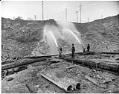
Workers using water hoses to regrade Denny Hill, Seattle, circa 1909
Workers in the first Denny Hill regrading project sometimes used high pressure jets of water to wash away the hill. Over five million gallons of water were pumped from Elliott Bay and Lake Union every day. The dirt was washed out into the bay through tunnels and flumes. Handwritten on sleeve: Regrade Denny Hill.Photographer's Reference Number: 9026
ID Number:1983.10.8127
Date:Circa 1909
Photograph
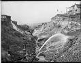
Using water hoses to regrade Denny Hill, circa 1909
Workers in the first Denny Hill regrading project sometimes used high pressure jets of water to wash away the hill. Over five million gallons of water were pumped from Elliott Bay and Lake Union every day. The dirt was washed out into the bay through tunnels and flumes.This photo was taken on Third Avenue in downtown Seattle in about 1909.…
ID Number:1983.10.8164
Date:Circa 1909
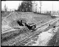
Photograph
Montlake Cut under construction, Seattle, circa 1914
The Lake Washington Ship Canal followed the routes of earlier canals and streams which connected Lake Washington, Lake Union, and Salmon Bay. This photo shows the Montlake Cut between Portage Bay, shown in the background, and Union Bay in about 1914, about three years after construction started. A steam shovel is excavating the hillside; the tracks were for a train…
ID Number:1983.10.8865
Date:Circa 1914
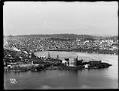
Photograph
Lake Union gasworks and University district, circa 1909
Private companies started supplying Seattle homes and businesses with natural gas in the early 1870s. At first, the gas was made from coal, which was brought in by railroad. It was used for lighting streets and buildings, as well as for cooking, heating, and manufacturing. One company built a plant at the north end of Lake Union in 1906. Parts…
ID Number:1983.10.8930.1
Date:Circa 1909
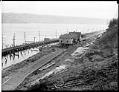
Photograph
Westlake Avenue, Seattle, circa 1911
Handwritten on sleeve: Westlake Av.Webster & Stevens number: 19179
ID Number:1983.10.9147
Date:Circa 1911
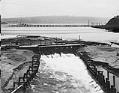
Photograph
Lake Washington Ship Canal spillway near Fremont, Seattle, circa 1911
During the building of the Lake Washington Ship Canal in Seattle, temporary dams were built at various places to control the water level. This photo shows the spillway of a temporary dam at the western end of Lake Union, near Fremont. Logs for a nearby lumber mill float behind the dam. The Stone Way Bridge is under construction in the…
ID Number:1983.10.9151
Date:Circa 1911
Photograph
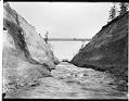
Montlake canal, Seattle, circa 1911
Before the building of the Lake Washington Ship Canal, a small canal connected Lake Washington with Lake Union's Portage Bay. This photo, taken around 1911, shows the canal in the Montlake area and a dam which controlled the water level. Handwritten on sleeve: Lake Wash. Canal.Photographer's Reference Number: 19269
ID Number:1983.10.9158
Date:Circa 1911
Photograph
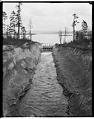
Lake Washington canal at Montlake, circa 1911
Before the building of the Lake Washington Ship Canal, a small canal connected Lake Washington with Lake Union's Portage Bay. This photo, taken around 1911, shows the canal in the Montlake area and a dam which controlled the water level. Webster Point, at Laurelhurst, is in the distant left. Webster & Stevens number: 19272
ID Number:1983.10.9159
Date:Circa 1911