844 results for: Puget Sound
Photograph
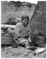
Puget Sound Salish basketmaker, circa 1900
Coast Salish peoples are a diverse group of Indigenous people of the Pacific Northwest who speak related languages and have some common cultural traditions. The Coast Salish grouping includes many different tribal groups, all with their own names for themselves and most with their own languages. Coast Salish peoples have lived in the Pacific Northwest since time immemorial and their…
ID Number:Lib1988.33.115
Date:Circa 1900
Photograph
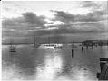
Boats in Elliott Bay, Seattle, circa 1898
Caption on image: Wilse.Photographer's Reference Number: 1183
ID Number:Lib1988.33.131
Date:Circa 1898
Photograph
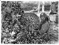
Woman with hop basket, circa 1900
From the late 1860s to the early 1890s, hop farming was an important activity in the valleys of the Puget Sound region, including Puyallup, White River, and Snoqualmie. Indigenous workers came from through the Pacific Northwest, Canada, and Alaska (but especially from regional tribes like the Puyallup, Snoqualmie, Muckleshoot, Duwamish, Sammamish, Lummi, and Nisqually) as a seasonal labor force to…
ID Number:Lib1988.33.139
Date:Circa 1900
Photograph
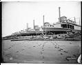
Steamships being built at Moran Brothers shipyard, Seattle, 1898
The Klondike gold rush brought lots of business to the Moran Brothers shipyard. In 1898, the company built twelve steamers to carry people and supplies on the Yukon River. The vessels were 175 feet long and 35 feet wide. They were built to be used in shallow river water, but they also had to be sturdy enough to make the…
ID Number:Lib1988.33.217
Date:1898
Photograph
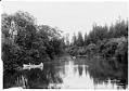
Canoes on Black River, circa 1898
Until 1916, the Black River linked Lake Washington with the Duwamish River, and the water was deep enough for steamboats to travel between towns on the lake and Puget Sound. After the lake was lowered in 1916, during construction of the Lake Washington Ship Canal, the Black River dried up and gradually disappeared. This photo shows the Black River as…
ID Number:Lib1988.33.238
Date:Circa 1898
Photograph
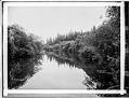
Black River, Seattle, circa 1899
Before the building of the Lake Washington Ship Canal lowered the level of Lake Washington, the Black River linked lake commerce with Puget Sound by way of the Duwamish River. After the lowering of the lake during the summer of 1916, the Black River dried up and gradually disappeared. This photo shows the Black River as it looked around 1898-1900.
ID Number:Lib1988.33.284
Date:Circa 1899
Photograph
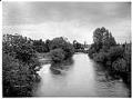
Black River with farmhouse in distance, circa 1899
Until 1916, the Black River linked Lake Washington with the Duwamish River, and the water was deep enough for steamboats to travel between towns on the lake and Puget Sound. After the lake was lowered in 1916, during construction of the Lake Washington Ship Canal, the Black River dried up and gradually disappeared. This photo shows the Black River as…
ID Number:Lib1988.33.286
Date:Circa 1899
Photograph
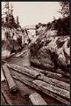
Logs passing through Montlake Ditch, Seattle, circa 1902
The Montlake Cut, between the Montlake and University District neighborhoods in Seattle, connects Lake Washington and Lake Union as part of the Lake Washington Ship Canal. When it was completed in 1916, it marked the realization of a 62-year-old idea to link the lakes with Puget Sound, creating a freshwater harbor in Seattle and a waterway connecting Seattle's shipping harbor…
ID Number:Lib1991.5.12
Date:Circa 1902
Photograph
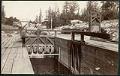
Wooden lock in Montlake Ditch, Seattle, circa 1900
The Montlake Cut, between the Montlake and University District neighborhoods in Seattle, connects Lake Washington and Lake Union as part of the Lake Washington Ship Canal. When it was completed in 1916, it marked the realization of a 62-year-old idea to link the lakes with Puget Sound, creating a freshwater harbor in Seattle and a waterway connecting Seattle's shipping harbor…
ID Number:Lib1991.5.14
Date:Circa 1900
Photograph
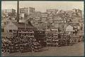
Wharf and beach homes on waterfront, Seattle, circa 1895
Predating the settlement that became the city of Seattle, the Duwamish had an encampment with two longhouses situated along the north central waterfront, roughly at the intersection of present-day Bell Street and Alaskan Way. By around the 1860s, the longhouses were gone, leaving only modest beach structures. In the 1890s the waterfront from Pike Street north to Broad Street had…
ID Number:Lib1991.5.78
Date:Circa 1895