771 results for: Transportation
Photograph
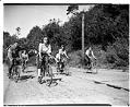
Seattle Bicycle Club outing, Seattle, 1947
Bicycles have been popular in the Seattle area since their introduction in the 1890s. The region's many cycling groups regularly sponsor outings along roads and bicycle trails.In this photo, taken on a sunny November day in 1947, members of the Seattle Bicycle Club cycle along an unidentified Seattle street. At that time, it was not at all unusual for women…
ID Number:PI26750
Date:1947
Photograph
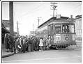
Children boarding Wallingford streetcar on its last run, Seattle, 1940
The Wallingford streetcar line connected downtown Seattle with the outlying areas of Wallingford and the University District. In May 1940, the streetcars stopped running and were replaced by buses. Signs in image: Spring Weather by the Ton - Ladysmith Wellington. Burn Carolyn Coal. Fur Storage at the Bon Marche.Handwritten on negative: Wallingford st car, last run.Handwritten on sleeve: Seattle -…
ID Number:PI27180
Date:1940
Photograph
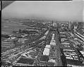
Aerial view of Alaskan Way Viaduct under construction from south, Seattle, 1957
Seattle's Alaskan Way Viaduct carried traffic over the waterfront area, linking the northern part of the city to the industrial area south of the central business district. The first unit of the elevated roadway, from Battery Street to Dearborn Street, was completed in 1953 and a southern extension in 1959. The Viaduct closed in January 2019 after being replaced by…
ID Number:PI27481
Date:1957
Photograph
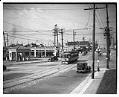
Intersection of Jackson Street at Fourteenth Avenue, Seattle, March 1936
A photographer from the Seattle Post-Intelligencer snapped this 1936 view of trolley car 805 at the intersection of Jackson Street and Fourteenth Avenue. Within the next four years, all of Seattle's streetcars and cable cars would be replaced by bus routes.
ID Number:PI27664
Date:1936
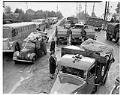
Photograph
U. S. soldiers and Japanese Americans preparing for forced removal, Bainbridge Island, March 30, 1942
In this image U. S. Army soldiers gather Japanese Americans at an assembly point on Bainbridge Island in preparing for transportation to the Puyallup Assembly Center. Civilian Exclusion Order No. 1 was issued at Bainbridge Island, ordering 227 residents of Japanese descent to leave with six days' notice. They departed by ferry on March 30, 1942. The island had a…
ID Number:PI28048
Date:1942
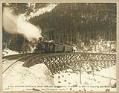
Photograph
First passenger train to summit of White Pass, February 20, 1899
On February 20, 1899, the first passenger train on the White Pass & Yukon Route crossed over the summit of White Pass. The railroad owners had targeted Christmas 1898 as the day they wanted to reach the summit, but brutal weather caused construction delays and drove some workers to quit.In this photo by Eric Hegg, the White Pass & Yukon…
ID Number:SHS38
Date:1899
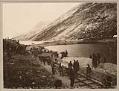
Photograph
White Pass & Yukon, laying at Bennett, track, 1899
On July 6, 1899, construction workers finally completed the White Pass & Yukon Route railroad line through White Pass to Lake Bennett, British Columbia. It took fourteen months to build the 40-mile railway line from Skagway, Alaska.This photo by Eric Hegg shows the laying of the last track on the White Pass & Yukon Route railroad between Skagway, Alaska, and…
ID Number:SHS40
Date:1899
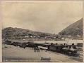
Photograph
Terminus of White Pass and Yukon Railroad at Bennett, British Columbia, August 5, 1899
The White Pass & Yukon Route railroad reached the shores of Lake Bennett on July 6, 1899. For a short time, freight and passengers transferred to steamboats at Bennett which carried them to Carcross. There, they boarded the train again for Whitehorse, and transferred to steamboats again to get to Dawson, the closest port to the Yukon gold fields. Eventually…
ID Number:SHS41
Date:1899
Photograph
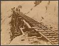
Icy tracks on the White Pass & Yukon Route, circa 1899
Winter snow in the coastal mountains was a constant problem for the White Pass and Yukon Route railway. Subzero temperatures, icy conditions, and snowfalls of several feet were common. The railroad's snowplows couldn't always get through, and sometimes passengers had to help clear the tracks.This photo by Eric Hegg shows workers clearing ice from the tracks of the White Pass…
ID Number:SHS42
Date:Circa 1899
Photograph
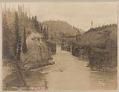
Miles Canyon, circa 1898
Miles Canyon was one of the most dangerous parts of the Yukon River between Lake Bennett and Dawson. It was only 100 feet wide, with steep cliffs, a whirlpool midway, and a large rock at the lower end. The gold rush stampeders could pay professional guides to take them through the canyon, but many couldn't afford the expense.This E. A.…
ID Number:SHS48
Date:1898