771 results for: Transportation
Photograph
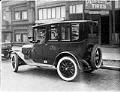
Yellow cab in front of Perfection Tires, Seattle, circa 1920
This image of a man driving a Yellow cab was taken in today's Broadway neighborhood, in front of Perfection Tires Sales Co., located at 1528 12th Avenue.This image comes from a photograph album entitled "The Swedes’ Life and Work in the State of Washington."
ID Number:2016.59.26
Date:Circa 1920
Photograph
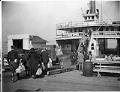
Passengers boarding the Leschi ferry, Seattle, circa 1920
This image shows people boarding the Leschi, a steam ferry that operated on Lake Washington between Kirkland and Seattle from 1913 to 1950, and afterward on Puget Sound until 1967. Steamboat operations on Lake Washington eventually became almost the sole province of one firm, Anderson Steamboat Company, founded by John L. Anderson (1868–1941), an immigrant from Sweden. Anderson’s company had…
ID Number:2016.59.31
Date:Circa 1920
Photograph
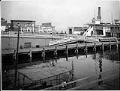
Lake Washington ferry dock at Leschi Park, Seattle, circa 1920
This image of the Leschi was taken at the main terminal at Leschi Park for Anderson Steamboat Company, founded by John L. Anderson (1868–1941), an immigrant from Sweden. Anderson’s company had over 50 stops on the lake. The Leschi was a steam ferry that operated on Lake Washington between Kirkland and Seattle from 1913 to 1950, and afterward on Puget…
ID Number:2016.59.32
Date:Circa 1920
Photograph
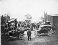
Ferry Issaquah launching, Kirkland, 1914
In 1914, the Anderson Steamboat Company launched the ferry "Issaquah." The vessel was one of the first in the Pacific Northwest designed to carry automobiles as well as horse drawn vehicles. Until 1918, the "Issaquah" sailed between Leschi, Mercer Island, and Newport, where it linked up with the new highway to North Bend. The "Issaquah" could also be rented for…
ID Number:2016.59.54
Date:1914
Photograph
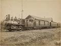
Seattle, Lake Shore & Eastern Railway train at Issaquah depot, circa 1890
The Seattle, Lake Shore & Eastern Railway incorporated in 1885 when a group of businessmen, headed by Thomas Burke, decided to invest in a line to connect downtown Seattle with points east. By 1889 the railroad had reached Snoqualmie Falls, where it linked to a northbound line. This photo shows a passenger train at the depot in Issaquah. Stamped on…
ID Number:2016.81.1
Date:Circa 1890
Photograph
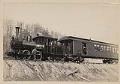
Seattle, Lake Shore & Eastern Railway locomotive and passenger car, Seattle, circa 1890
The Seattle, Lake Shore & Eastern Railway incorporated in 1885 when a group of businessmen, headed by Thomas Burke, decided to invest in a line to connect downtown Seattle with points east. By 1889 the railroad had reached Snoqualmie Falls, where it linked to a northbound line. A passenger station on Railroad Avenue and a working yard at Interbay formed…
ID Number:2016.81.4
Date:Circa 1890
Photograph
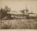
Seattle, Lake Shore & Eastern locomotive S.V. White at Interbay yard, circa 1890
The Seattle, Lake Shore & Eastern Railway incorporated in 1885 when a group of businessmen, headed by Thomas Burke, decided to invest in a line to connect downtown Seattle with points east. By 1889 the railroad had reached Snoqualmie Falls, where it linked to a northbound line. A passenger station on Railroad Avenue and a working yard at Interbay formed…
ID Number:2016.81.5
Date:Circa 1890
Photograph
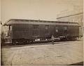
Seattle, Lake Shore & Eastern baggage car, Seattle, circa 1890
The Seattle, Lake Shore & Eastern Railway had a passenger depot and freight office at the foot of Madison Street along the waterfront. This photo shows a railroad employee standing in front of a baggage car near that location.
ID Number:2016.81.6
Date:Circa 1890
Photograph
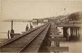
Seattle, Lake Shore & Eastern tracks heading north from Seattle, circa 1890
The Seattle, Lake Shore & Eastern Railway incorporated in 1885 when a group of businessmen, headed by Thomas Burke, decided to invest in a line to connect downtown Seattle with points east. By 1889 the railroad had reached Snoqualmie Falls, where it linked to a northbound line. A passenger station on Railroad Avenue and a working yard at Interbay formed…
ID Number:2016.81.9
Date:Circa 1890
Photograph
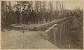
Group of men on Seattle, Lake Shore & Eastern Railway line, 1887
The Seattle, Lake Shore & Eastern Railway extended from the waterfront along the northern shore of Lake Union and then to the north side of Lake Washington, eventually reaching Snoqualmie Falls. In this photo, a group of investors inspect the progress of the line on the way to Woodinville. Colonel A. B. Rogers stands in the center foreground with white…
ID Number:2016.81.10
Date:1887