432 results for: Construction and Urban Planning
Cartographic material
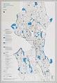
Open Space Proposed Zoning Map, Seattle, December 1985
Since the beginning of the twentieth century, the City of Seattle showed interest in purposefully growing the city. In 1903 the city contracted the Olmsted Brothers to create a comprehensive Seattle park and boulevard system, and in 1910 hired Virgil G. Bogue to prepare a strategic plan. The Seattle Zoning Commission was created in 1920 to divide the city into…
ID Number:2019.3.19
Date:1985
Cartographic material
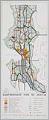
Comprehensive plan of Seattle, September 1956
In the late 1940s, Seattle’s City Planning Commission began work on a comprehensive plan for the city in order to plan its future development and growth. The results, in the form of a map, were presented to the mayor in October 1956 and accepted in principle by the City Council in April 1957. The plan had three major parts: land…
ID Number:2019.3.26
Date:1956
Poster
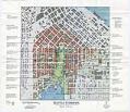
Seattle Commons Draft Plan poster, 1992
In 1991 Seattle architect Fred Bassetti and Seattle Times columnist John Hinterberger first proposed the idea for a 61-acre park stretching from downtown Seattle to Lake Union, envisioning a vast civic lawn framed by high-tech laboratories, condos, restaurants, and urban amenities. Microsoft co-founder Paul Allen donated $20 million to buy property for the Seattle Commons, but the plan eventually failed…
ID Number:2020.51.2.1
Date:1992
Cartographic material
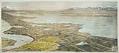
Birdseye View of Lake Forest Park and Seattle, 1910
The land that is now Lake Forest Park was originally occupied by a winter village of the Snohomish tribe, which increasing white settlement displaced in the late 19th century. In 1909, property developer (and future Seattle mayor) Ole Hanson formed the North Seattle Improvement Company and began buying land at the north end of Lake Washington in order to build…
ID Number:2023.3.4
Date:1910
Poster
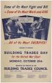
Building Trades Day for the United War Chest poster, 1942
This poster advertises Building Trades Day for the United War Chest, held on Monday, October 19, 1942, during World War II. On this day, men working on building and construction projects were asked to give a day's pay to the War Chest. Unions donated generously, with many receiving "E" (for excellence) banner blue ribbon awards. Text on poster: Some of…
ID Number:2024.15.1
Date:1942
Photograph
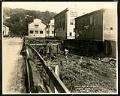
View of Holgate Street looking east at 9th Avenue South, Seattle, May 22, 1923
This photograph of Holgate Street looking east towards Beacon Hill depicts two workmen at ground level, perhaps working on the pilings which raise the street and buildings above the marshy ground. Other pedestrians are also visible. This area south of downtown Seattle was originally made up of tidal flats; soil dredged from the Duwamish River and sluiced from the Denny…
ID Number:Lib1988.13.7.2.19
Date:1923
Photograph
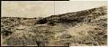
Beacon Hill regrading, Seattle, July 2, 1923
This photograph shows the north end of Beacon Hill facing north. Dearborn Street is visible coming from the left center edge of the frame, between Beacon Hill and what will later be the Chinatown - International District of Seattle. Advertisement billboards visible in the image are for Wrigley's Gum and Wing Foot Tires. This area south of downtown Seattle was…
ID Number:Lib1988.13.7.2.58
Date:1923
Photograph
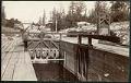
Wooden lock in Montlake Ditch, Seattle, circa 1900
The Montlake Cut, between the Montlake and University District neighborhoods in Seattle, connects Lake Washington and Lake Union as part of the Lake Washington Ship Canal. When it was completed in 1916, it marked the realization of a 62-year-old idea to link the lakes with Puget Sound, creating a freshwater harbor in Seattle and a waterway connecting Seattle's shipping harbor…
ID Number:Lib1991.5.14
Date:Circa 1900
Photograph
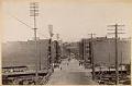
Facing north on Commercial Street, Seattle, circa 1895
This image, taken facing north along Commercial Street (now First Avenue South), shows Seattle's central business district, likely a few years after the Great Fire of 1889. The street in the foreground crossing the frame from left to right is likely Jackson Street, visibly raised above ground level like many streets were after the fire. The brick building in the…
ID Number:Lib1991.5.26
Date:Circa 1895
Photograph
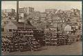
Wharf and beach homes on waterfront, Seattle, circa 1895
Predating the settlement that became the city of Seattle, the Duwamish had an encampment with two longhouses situated along the north central waterfront, roughly at the intersection of present-day Bell Street and Alaskan Way. By around the 1860s, the longhouses were gone, leaving only modest beach structures. In the 1890s the waterfront from Pike Street north to Broad Street had…
ID Number:Lib1991.5.78
Date:Circa 1895