771 results for: Transportation
Photograph
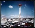
Space Needle and monorail, Seattle, World's Fair, 1962
A number of the structures built for the 1962 World's Fair have become Seattle icons. Here, one can see three in the same view: the Space Needle, the Monorail, and the airy white arches of the U.S. Science Pavilion (now the Pacific Science Center). Handwritten on sleeve: Space Needle & Monorail.
ID Number:1965.3598.26.2
Date:1962
Photograph
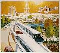
Artist's rendering of monorail, Seattle World's Fair, circa 1962
This photograph documents an artist rendering of the Seattle Monorail and the World's Fair. The purpose is uncertain. It was probably intended for a promotional poster, publication, or advertisement. Handwritten on sleeve: Artist's concept of Monorail.
ID Number:1965.3598.26.6
Date:Circa 1962
Photograph
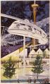
Conceptual artwork for the monorail, Seattle World's Fair, circa 1961
This photograph documents an artist's concept of the fair with the Monorail and Space Needle. In this image, the Monorail hangs from its track rather than gliding upon it. Caption information source: Becker, Paula, and Alan Stein. The future remembered: The Seattle World's Fair and its legacy. Seattle: Seattle Center Foundation, 2011. Page 38.
ID Number:1965.3598.26.35
Date:Circa 1961
Cartographic material
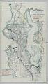
Map of the City of Seattle and Adjacent Territory, Bogue Map No. 2, September 1911
The Municipal Plans Commission of Seattle, established in 1910, hired civil engineer Virgil Gay Bogue (1846-1916) to prepare a strategic development plan for the city. Bogue's 1911 proposal was very ambitious, including a Civic Center in the Denny Regrade area, a park and boulevard system, separation of railroad tracks from streets, and a variety of other municipal improvements. Bogue's "Plan…
ID Number:1966.3805.1
Date:1911

Photograph
Seattle waterfront from Elliott Bay, 1917
The panoramic image shown here was taken from Elliott Bay, facing east towards the Seattle waterfront. Magnolia and Queen Anne Hill are visible at the left edge of the frame, and Capitol Hill and First Hill can be seen behind the Pioneer Square area near the right edge of the frame. Handwritten on image: The Seattle Waterfront, Pierson & Co.…
ID Number:1966.3862.1
Date:1917
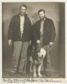
Photograph
Charles "Slim" Williams, John Logan, and dog "Blizzard," December 9, 1939
This photo depicts Slim Williams (left) and John Logan with their dog "Blizzard" after their arrival in Seattle by motorcycle in December 1939. Clyde C. "Slim" Williams was a promoter of the Alaska Highway in the 1930s. Williams first rode the proposed route in 1933, by dogsled and in a Model T pulled by sled dogs, from Copper Center, Alaska…
ID Number:1966.3948.128
Date:1939
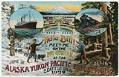
Postcard
Alaska-Yukon-Pacific Exposition promotional postcard, Seattle, circa 1909
Promotional photograph for the Alaska-Yukon-Pacific Exposition in Seattle, with illustrations connecting Seattle to Alaska (including with an Alaska Native totem pole), which encourages people to arrive by steamship and railroad. Caption on image: Hello Bill! Meet me on the Pay Streak at the Alaska Yukon Pacific Exposition - June 1st - Oct 16th - Seattle U.S.A. 1909.Postcard Number: 1853
ID Number:1966.4058.8
Date:Circa 1909
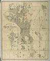
Cartographic material
Anderson Map Co.'s Official Map of Greater Seattle, 1909
Seattle entrepreneur and amateur photographer O.P. (Oliver Phelps) Anderson (1859-1941) was the son of Alexander Jay Anderson (1832-1903), president of the Washington Territorial University (now University of Washington) from 1877-1882. O.P. trained as a draughtsman and by 1890 had started a civil engineering and map publishing business, O. P. Anderson & Company (later O. P. Anderson Map & Blue Print…
ID Number:1969.4750.1
Date:1909
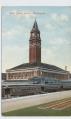
Postcard
King Street Station, Seattle, circa 1911
Seattle's King Street Station was built between 1904 and 1906 for the Great Northern Railroad. The St. Paul, Minnesota, architectural firm of Reed & Stem designed the station, patterning its tall clock tower after a famous bell tower in Venice, Italy. This mimicry of European architecture added a touch of tradition and heritage to Seattle's growing downtown area. Caption on…
ID Number:1969.4756.14
Date:Circa 1911
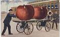
Postcard
Men with giant apples, 1907
This color postcard shows two men pulling two oversized apples on a cart up to a Great Northern Railway railcar. Caption on image: Expressing Washington Apples.Copyright 1907
ID Number:1969.4769.1
Date:1907