259 results for: Restaurants
Document
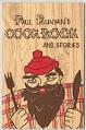
Paul Bunyan's Cookbook and Stories, circa 1962
Featuring an image of Paul Bunyan on the front, this small cookbook was published by Seattle Restaurant Food Supply, led by Walter F. Clark. Clark was a Seattle restauranteur and nationally acclaimed for putting Seattle on the food map. The legendary Paul Bunyan inspired the recipes in this booklet, and also had a prominent place at the Seattle World's Fair,…
ID Number:1980.7051.122
Date:Circa 1962
Photograph
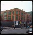
Businesses on Yesler Way near Occidental Ave S., 1967
This photograph, taken around 1967, shows the intersection of Yesler Way and Occidental Ave South. The building shown was originally named the Sanderson Block and it was constructed shortly after the Great Seattle Fire in 1889 to replace a wooden structure that had burned in the fire. It has been home to the Merchant's Cafe since opening in 1890, making…
ID Number:1980.7067.1.22.1
Date:1967
Photograph
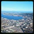
Aerial view of Lake Union, taken from the southwest, Seattle, 1967
In 1882, lumber mills, shipyards, and other industries began to move north from Seattle’s waterfront to the shores of Lake Union. Industrial development continued with Seattle’s growth but shrank after World War II. A few shipyards remained by the late 1960s, plus some light industry, apartments, parking lots, fast food restaurants, marinas, and a seaplane terminal. Roads were built and…
ID Number:1980.7067.1.24.1
Date:1967
Photograph
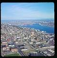
Aerial view of Lake Union looking northeast, Seattle, 1967
In 1882, lumber mills, shipyards, and other industries began to move north from Seattle’s waterfront to the shores of Lake Union. Industrial development continued with Seattle’s growth but shrank after World War II. A few shipyards remained by the late 1960s, plus some light industry, apartments, parking lots, fast food restaurants, marinas, and a seaplane terminal. Roads were built and…
ID Number:1980.7067.1.29.1
Date:1967
Photograph
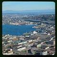
Aerial view of South Lake Union looking northeast, Seattle, 1967
In 1882, lumber mills, shipyards, and other industries began to move north from Seattle’s waterfront to the shores of Lake Union. Industrial development continued with Seattle’s growth but shrank after World War II. A few shipyards remained by the late 1960s, plus some light industry, apartments, parking lots, fast food restaurants, marinas, and a seaplane terminal. Roads were built and…
ID Number:1980.7067.1.36.1
Date:1967
Photograph
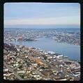
Aerial view of the northern part of Lake Union, looking northeast, Seattle, 1967
In 1882, lumber mills, shipyards, and other industries began to move north from Seattle’s waterfront to the shores of Lake Union. Industrial development continued with Seattle’s growth but shrank after World War II. A few shipyards remained by the late 1960s, plus some light industry, apartments, parking lots, fast food restaurants, marinas, and a seaplane terminal. Roads were built and…
ID Number:1980.7067.1.36.2
Date:1967
Photograph
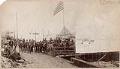
Men posing outside Jewel Saloon after Great Seattle Fire, June 1889
The Great Fire of June 6, 1889 was a significant turning point in Seattle's history and changed both the physical and political landscapes of the City. The fire completely consumed 100 acres of Seattle's business district and waterfront. The city didn't take much time to mourn; most businesses decided to rebuild where they had been, and quickly set up tents…
ID Number:1980.7092.1
Date:1889
Photograph
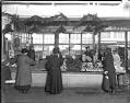
Valley Vegetable Gardens stall at Pike Place Market, Seattle, circa 1928
Before the Pike Place Market opened in 1907, King County farmers had a harder time making a steady income. They either had to sell their produce to wholesalers or travel to town to sell directly to hotels, restaurants, and residents. If no buyers were found, the fruits and vegetables were left to rot. The market gave farmers a permanent place…
ID Number:1983.10.140.3
Date:Circa 1928
Photograph
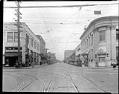
University Way, looking north from 45th Street, circa 1927
University Way, nicknamed "The Ave" is the business district closest to the University of Washington. University students, faculty, and staff can easily walk to the University Bookstore, restaurants, banks, and other businesses in the area. This photo shows The Ave, with its streetcar tracks, in about 1927. The tiled building on the left corner is now a jewelry store. The…
ID Number:1983.10.791
Date:Circa 1927
Photograph
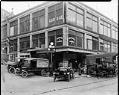
South End Public Market, Seattle, circa 1919
The South End Public Market operated at Washington Street and Third Avenue South. The market's offerings included restaurants, fresh produce, fresh and cured meats, and free delivery. The horse team in the lower right are turned perpendicular to the delivery wagon they are pulling so that they don't block street traffic. Signs in image: United Shoe Repairing. M.J.B. Coffee -…
ID Number:1983.10.1376
Date:Circa 1919