3506 results for: Seattle Photographic Co.
Photograph
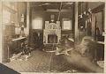
Living room of the B.F. Middleton home in South Park, Seattle, circa 1895
B.F. (Benjamin Franklin) Middleton, an Iowa native, moved to California and then to the Seattle area after the 1889 Seattle Fire. He settled in South Park in the Duwamish Valley in 1893 and ran a large grocery business and general store at 8207 Dallas Avenue in South Park’s business district.In 1894, the Middleton family built a wood frame house at…
ID Number:2019.92.4
Date:1895
Photograph
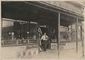
Merl Middleton at front door of Middleton Grocery, Seattle, circa 1910
B.F. (Benjamin Franklin) Middleton, an Iowa native, moved to California and then to the Seattle area after the 1889 Seattle Fire. He settled in South Park in the Duwamish Valley in 1893 and ran a large grocery business and general store at 8207 Dallas Avenue in South Park’s business district.In this image, Merl Middleton, B.F. Middleton’s eldest child, stands at…
ID Number:2019.92.5
Date:1910
Photograph
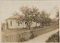
B.F. Middleton home, South Park, Seattle, circa 1895
B.F. (Benjamin Franklin) Middleton, an Iowa native, moved to California and then to the Seattle area after the 1889 Seattle Fire. He settled in South Park in the Duwamish Valley in 1893 and ran a large grocery business and general store at 8207 Dallas Avenue in South Park’s business district.In 1894, the Middleton family built a wood frame house at…
ID Number:2019.92.6
Date:1895
Photograph
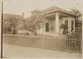
B.F. Middleton home, South Park, Seattle, circa 1905
B.F. (Benjamin Franklin) Middleton, an Iowa native, moved to California and then to the Seattle area after the 1889 Seattle Fire. He settled in South Park in the Duwamish Valley in 1893 and ran a large grocery business and general store at 8207 Dallas Avenue in South Park’s business district.In 1894, the Middleton family built a wood frame house at…
ID Number:2019.92.7
Date:1905
Photograph
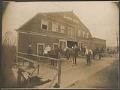
Mortensen Livery Barn in South Park, Seattle, circa 1907
South Park is located south of Seattle on the west bank of the Duwamish River. Once a separate city, it became part of Seattle in 1907, around the time this photo was taken. During this period, many of South Park’s residents were farmers who supplied produce to Seattle’s Pike Place Market. Mortensen’s Livery Stable, shown here, would have been a…
ID Number:2019.92.8
Date:1907
Photograph
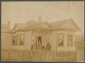
B.F. Middleton home, South Park, Seattle, circa 1895
B.F. (Benjamin Franklin) Middleton, an Iowa native, moved to California and then to the Seattle area after the 1889 Seattle Fire. He settled in South Park in the Duwamish Valley in 1893 and ran a large grocery business and general store at 8207 Dallas Avenue in South Park’s business district.The Middleton family built a wood frame house in South Park…
ID Number:2019.92.9
Date:1895
Photograph
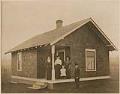
Berg family in front of a house, Seattle, circa 1909
Engineer Norman Berg came to Seattle as assistant construction manager for the Seattle Electric Company’s new power station in Georgetown. He married Emma (alternate spelling Erma) T. Middleton in August 1906. In this image, Norman, Erma and Norma (also called Honey) Berg stand outside a house, probably in the South Park or Georgetown areas. Specific figures have not been named,…
ID Number:2019.92.10
Date:1909
Photograph
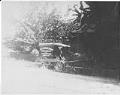
B.F. Middleton Groceries cart, Seattle, circa 1900
B.F. Middleton moved to Seattle after the 1889 Great Fire and settled in South Park in the Duwamish Valley in 1893. He ran a large grocery business and general store at 8207 Dallas Avenue in South Park’s business district. This image shows the store’s horse-drawn delivery wagon. Caption information source: The Seattle Daily Times: November 11, 1956, p. 57.
ID Number:2019.92.11
Date:1900
Photograph
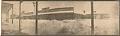
B.F. Middleton grocery in the snow, Seattle, February 1916
A huge blizzard hit Seattle on February 2, 1916, dropping over 21 inches of snow on top of some already there. This view, taken in South Park from behind shoveled snow, looks across Dallas Avenue at the B.F. Middleton general store across the street.
ID Number:2019.92.12
Date:1916
Photograph
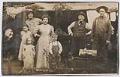
Middleton family, Seattle, circa 1910
B.F. (Benjamin Franklin) Middleton, an Iowa native, moved to California and then to the Seattle area after the 1889 Seattle Fire. He settled in South Park in the Duwamish Valley in 1893 and ran a large grocery business and general store at 8207 Dallas Avenue in South Park’s business district.In this image, Emma Middleton, Ben Middleton, Bill Middleton, and Edith…
ID Number:2019.92.13
Date:1910