672 results for: Lake Washington
Cartographic material
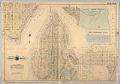
Baist's Real Estate Atlas of Surveys of Seattle, Plate 12, 1908
The G. William Baist Company of Philadelphia produced real estate and insurance maps of over twenty different cities across the United States between the 1880s and 1967. The company published atlases in Seattle in 1905, 1908, and 1912, illustrating property ownership, building materials and improvements, and transportation routes.This map, labeled Plate 12, was separated from the atlas, and shows the…
ID Number:1985.4.13
Date:1908
Audio recording
Oral history interview with Wilfred Miller, Nels Nelson, and Roy St. Clair, January 17, 1985
Interview with Wilfred Miller, Nels Nelson, and Roy St. Clair about their employment at the Lake Washington Shipyards. Topics discussed include the production changes brought by war, the shortage of Navy inspectors, worker wages, working conditions, safety standards, women welders, union activity, and a worker strike prior to Pearl Harbor.The interview conducted by Lorraine McConaghy for the Life on the…
ID Number:1985.134.15
Date:1985
Videorecording
Oral history interview with Jim Ellis, March and July 1985
James Reed “Jim” Ellis (b. 1921) is widely regarded as the most visionary civic activist in King County history.Born in California, Ellis family moved to Seattle with his family in 1923. He attended John Muir Elementary School and Franklin High School, and graduated from the University of Washington School of Law in 1948.In the 1950s, Ellis was a leader in…
ID Number:1985.135.9
Date:1985
Videorecording
Oral history interview with Horace W. McCurdy, January 18, 1985
Horace Winslow (“H.W.”) McCurdy (1899-1989) was a maritime construction executive, civic leader, and avid supporter of maritime research in the Pacific Northwest. A Washington native, McCurdy was born and raised in Port Townsend, and attended University of Washington in Seattle and the Massachusetts Institute of Technology (MIT). After graduating in 1922, he got a job at the Puget Sound Bridge…
ID Number:1985.135.17
Date:1985
Photograph
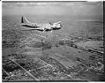
Aerial view of an early Boeing B-17E in flight, Seattle, 1941
The redesigned B-17E differed from previous models in that it included an enlarged tail, more guns and extra armor. It also included a tail gunner position, reducing its vulnerability from the rear. Only about 500 B17Es were built. This view looks northeast from the Magnolia area, showing the Ballard bridge below and Green Lake in the distance. Date photograph was…
ID Number:1986.5.186.1
Date:1941
Photograph
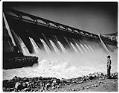
Open spillway at the Grand Coulee Dam, Columbia River Basin, Washington, 1942
Grand Coulee is the largest dam in the Columbia River Basin, about 90 miles northwest of Spokane. Construction began in 1933 and was completed in 1941. A hydroelectric dam with four power plants and an average annual energy output of about 2,300 megawatts, Grand Coulee produces enough power to continuously supply the needs of two cities the size of Seattle.…
ID Number:1986.5.3867.1
Date:1942
Photograph
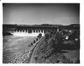
Grand Coulee Dam, Columbia River Basin, Washington, 1942
Grand Coulee is the largest dam in the Columbia River Basin, about 90 miles northwest of Spokane. Construction began in 1933 and was completed in 1941. A hydroelectric dam with four power plants and an average annual energy output of about 2,300 megawatts, Grand Coulee produces enough power to continuously supply the needs of two cities the size of Seattle.…
ID Number:1986.5.3867.2
Date:1942
Photograph
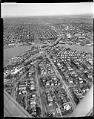
Aerial of freeway bridge under construction, Seattle, 1959
This aerial view shows the initial construction phase of the Tacoma-Seattle-Everett Freeway that was to become Interstate 5 (I-5). Bridge piers stand on either side of the Lake Washington Ship Canal. The University Bridge sits to the right of the new piers, which were used to construct a 4,429-foot-long bridge completed in fall 1961. Construction of the Tacoma-Seattle-Everett freeway, which…
ID Number:1986.5.3998.1
Date:1959
Photograph
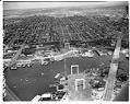
Aerial view looking north from the freeway bridge under construction, Seattle, 1959
This aerial view shows construction phase of the Tacoma-Seattle-Everett Freeway that was to become Interstate 5 (I-5). Bridge piers stand on either side of the Lake Washington Ship Canal. The 4,429-foot-long bridge completed in fall 1961.Construction of the Tacoma-Seattle-Everett freeway, which opened to traffic in December 1962, took up 6,600 parcels of land, 4,500 of them in Seattle. In 1958-59,…
ID Number:1986.5.4000.2
Date:1959
Photograph
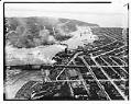
Aerial view of Ballard looking west, Seattle, 1937
The first Ballard Bridge opened in December 1917, crossing the Lake Washington Ship Canal and linking the Ballard district by road to Seattle. This aerial photo shows the Ballard Bridge and Salmon Bay, with the Hiram M. Chittenden Locks and Puget Sound at the top of the image. Log rafts floating in the bay are visible at the bottom left…
ID Number:1986.5.7332.1
Date:1937