19 results for: Laidlaw, Charles R.
Photograph
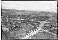
Aerial view from the southeast, looking across Georgetown to West Seattle, 1936
Georgetown is located south of downtown Seattle in the Duwamish River Valley. This image shows an area of Beacon Hill, above Georgetown's commercial area and the railroad. Seventeenth Avenue South is partially paved as it heads north, past a large natural gas storage tank and the North Coast Chemical & Soap Works plant. New sidewalks have been built along Seventeenth…
ID Number:1983.10.17774.3
Date:1936
Photograph
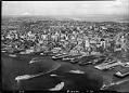
Aerial of waterfront and downtown from west, Seattle, September 15, 1936
This aerial view of Seattle's downtown has been retouched to add the ferry Kalakala and other vessels. Caption on border: Laidlaw.Handwritten on sleeve: Seattle & Harbor with boats.Webster & Stevens number: T-731
ID Number:1983.10.17806
Date:1936
Photograph
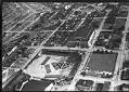
Aerial of National Guard Armory, Seattle, June 29, 1939
This aerial view looks south and west on what would later become the World's Fairgrounds, with the the Civic Auditorium and field in the foreground and the Armory (now the Center House) in the center. Handwritten on sleeve: 6-29-39 National Guard Armory.Photographer's number: T-921
ID Number:1983.10.17888
Date:1939
Photograph
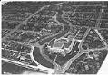
Aerial of Franklin High School and Mount Baker neighborhood looking south, Seattle, May 31, 1932
Franklin High School opened in the fall of 1912 in Seattle's Mount Baker area. The new school had 42 classrooms, two gymnasiums, a library, a home economics model apartment, and a 1,300 seat auditorium. When it opened, the school had 769 students, but the student body grew quickly. The school was built in the popular Renaissance Revival style, and was…
ID Number:1983.10.17937
Date:1932
Photograph
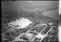
Aerial view of Denny regrade area, Seattle, 1931
Seattle's present-day Denny Triangle neighborhood was created between 1897-1930 by removing Denny Hill in stages. The neighborhood is located in the triangle formed by Denny Way on the north, Third Avenue on the southwest, and Olive Way on the southeast. This aerial view of the newly cleared neighborhood faces south towards downtown Seattle. It was taken after completion of the…
ID Number:1983.10.17948
Date:1931
Photograph
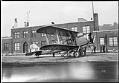
Air mail plane at Boeing Field, Seattle, circa 1933
In the 1920s, King County voters passed a bond issue to buy land for a commercial airport south of Seattle. Low lying land was graded with fill dredged from the Duwamish Waterway. The new airport, Boeing Field, was dedicated in July 1928. By 1938, the field served three major airlines, passenger planes and airborne freight carriers. Boeing Field is also…
ID Number:1983.10.17984.8
Date:Circa 1933
Photograph
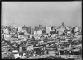
Downtown and Mount Rainier, Seattle, July 21, 1939
Handwritten on sleeve: City view looking south 7/21/39Webster & Stevens number: 220
ID Number:1983.10.18023
Date:1939
Photograph
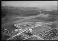
Aerial of Ford Motor Plant from southeast, Seattle, 1932
Photographer Charles Laidlaw made this view of the second Ford factory from about 800 feet above the Duwamish industrial area. Seattle's newest producer of Fords built only a few thousand cars before the Great Depression stopped the assembly line. The building was later used as a sales and service facility; in 1942 it was sold to the federal government. Caption…
ID Number:1983.10.18041.2
Date:1932
Postcard
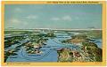
Aerial view of the Puget Sound Area postcard, circa 1938
This image shows a C.T. (Curt Teich) Art-Colortone postcard which uses a colorized version of a Charles R. Laidlaw aerial photograph of the Puget Sound area, and labels points of interest and ferry routes. The ferry routes help date the postcard between 1935 and 1942. The Fletcher Bay to Brownsville ferry route (center at left) only operated between 1924 and…
ID Number:2021.71.1
Date:Circa 1938