3246 results for: Seattle Post-Intelligencer
Photograph
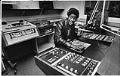
Student Eddie Releford in Cleveland High School's radio/television studio, Seattle, November 25, 1979
In the late 1970s, community and Seattle School District planners worked on a 1990 building plan to be adopted the following year. Faced with shrinking enrollments and the need to desegregate, they recommended that a number of schools, including Cleveland High School, on Seattle’s Beacon Hill, be shut down and teachers and students be moved to other schools. Cleveland students…
ID Number:2000.107.186.14.01
Date:1979
Photograph
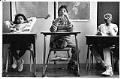
Students sitting in classroom at First Place, Seattle, May 30, 1991
In this image Gioconda, 10, and her brother Edgar, 11, rehearse a spelling test at First Place, a nonprofit educational program for homeless children, while their classmate on the right appears to be thinking more about the swimming trip scheduled to follow the spelling test. When First Place opened in 1989, it was Seattle's sole confidential educational program for homeless…
ID Number:2000.107.186.24.01
Date:1991
Photograph
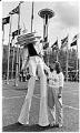
"Spacie" mascot and Century 21 baby at Seattle Center, April 21, 1983
When Jamie Williams was born one second past midnight on the opening day of Seattle’s 1962 World’s Fair, the Seattle Post-Intelligencer named her “Seattle’s Century 21 Baby.” On April 21, 1983, Jamie’s 21st birthday, Seattle Center invited her back for a gala birthday dinner at the Space Needle restaurant. She and her mother also toured the Seattle Center grounds with…
ID Number:2000.107.187.32.01
Date:1983
Photograph
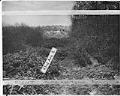
View of sanitary landfill on 43rd. Ave. S. looking south, Seattle, December 1942
This image shows a sanitary landfill on 43rd Ave S between Genesee St. and Lake Washington Boulevard. A sanitary landfill, or fill, was a type of garbage dump in which trash was deposited, spread out and compacted, then covered in several inches of dirt. The city had proposed to expand the fill eastward to 45th Ave S, but residents of…
ID Number:2000.107.188.33.01
Date:1942
Photograph
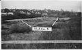
View of sanitary landfill on 43rd. Ave. S. looking west, Seattle, December 1942
This image shows a sanitary landfill on 43rd Ave S between Genesee St. and Lake Washington Boulevard. A sanitary landfill, or fill, was a type of garbage dump in which trash was deposited, spread out and compacted, then covered in several inches of dirt. The city had proposed to expand the fill eastward to 45th Ave S, but residents of…
ID Number:2000.107.188.33.02
Date:1942
Photograph
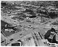
Aerial view of South Lake Union neighborhood looking northeast, 1953
The shores of Lake Union were inhabited by the Duwamish people since time immemorial. They called the lake “meman hartshu” meaning “little lake” and had several settlements surrounding it. Seattle’s Cascade or South Lake Union (SLU) neighborhood began growing quickly in the 1880s, as the city expanded north from downtown. Industrial activity on the lake increased in the early 1900s…
ID Number:2000.107.188.36.01
Date:1953
Photograph
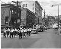
Funeral procession for Yee Wai Yee, July 14, 1953
Yee Wai Yee was a Chinese-American businessman who owned the Golden Dragon Café in Tacoma. He was also involved and well-liked in the Chinese communities of both Seattle and Tacoma. Yee was an active member of the Chinese Nationalist Party and was president of the Hop Sing Tong, a social organization among Chinese-Americans. Yee died in Sacramento on July 3,…
ID Number:2000.107.188.37.01
Date:1953
Photograph
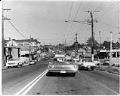
Street in the Central Area, Seattle, May 8, 1969
The Central Area (also called the Central District or the CD) is one of the oldest residential neighborhoods in Seattle. Known historically as Seattle’s Black neighborhood, other ethnic groups also called the Central Area home in the early 20th century. Urban development in the area first accelerated in the 1890s, as Seattle’s population rapidly grew. The first settlers were mostly…
ID Number:2000.107.189.01.01
Date:1969
Photograph
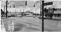
Intersection of Beacon Avenue S. and 15th Avenue S., 1974
Beacon Hill was originally inhabited by the Duwamish people, who had a village called Tal-tal-kus at the western foot of the hill. Settlers began moving onto Beacon Hill in the 1850s and growth accelerated around the turn of the 20th century. Starting in the 1920s, Chinese, Italian, and Japanese immigrants settled in Beacon Hill. After World War II, the trend…
ID Number:2000.107.189.08.01
Date:1974
Photograph
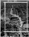
Aerial view of Empire Way and Sick's Stadium, July 11, 1953
Empire Way’s route was first laid out in 1913, as a state highway heading southeast out of Seattle. It was named for James J. Hill, the head of the Great Northern Railway, who was nicknamed the “Empire Builder.” At first, Empire Way was put together from parts of older roads on the same route. From the 1930s to the 1950s,…
ID Number:2000.107.189.11.01
Date:1953