432 results for: Construction and Urban Planning
Photograph
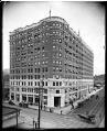
White-Henry Building, circa 1910
After the University of Washington moved to its present campus, it put together a master plan for the development of its downtown Seattle property. The plan included office buildings, a theater, a hotel, and stores. The White and Henry Buildings are two of three connected office buildings built along Fourth Avenue as part of this plan.This photo shows the White…
ID Number:1983.10.8477
Date:Circa 1910
Photograph
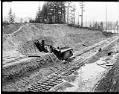
Montlake Cut under construction, Seattle, circa 1914
The Lake Washington Ship Canal followed the routes of earlier canals and streams which connected Lake Washington, Lake Union, and Salmon Bay. This photo shows the Montlake Cut between Portage Bay, shown in the background, and Union Bay in about 1914, about three years after construction started. A steam shovel is excavating the hillside; the tracks were for a train…
ID Number:1983.10.8865
Date:Circa 1914
Photograph
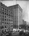
New York Block and Alaska Building, Seattle, circa 1910
The New York Block was one of a number of brick and stone buildings built just after Seattle's Great Fire of 1889. It was seven stories tall and was located at the northeast corner of Second Avenue and Cherry Street. The 14-story Alaska Building across the street was built in 1904. This office building was Seattle's first skyscraper to be…
ID Number:1983.10.8968
Date:Circa 1910
Photograph
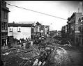
Street under construction, Seattle, circa 1909
Signs in image: Edison Phonographs. [...] Furniture. Children's Sleighs at Factory Prices. [...] Ward Real Estate. McIntyre Block. McLaughlin & [McLe...]. Handwritten on sleeve: Street Construction & Regrade (4th Ave?)Webster & Stevens number: 18091
ID Number:1983.10.9069
Date:Circa 1909
Photograph
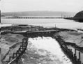
Lake Washington Ship Canal spillway near Fremont, Seattle, circa 1911
During the building of the Lake Washington Ship Canal in Seattle, temporary dams were built at various places to control the water level. This photo shows the spillway of a temporary dam at the western end of Lake Union, near Fremont. Logs for a nearby lumber mill float behind the dam. The Stone Way Bridge is under construction in the…
ID Number:1983.10.9151
Date:Circa 1911
Photograph
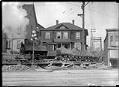
Regrade dirt train, circa 1913
Earth was moved in a variety of ways during Seattle's regrading projects. In this photo, taken around 1913, an engine pulls cars full of dirt along a track. Some of these rail lines were movable and could be shifted to wherever they were needed. Webster & Stevens number: 20062
ID Number:1983.10.9298
Date:Circa 1913
Photograph
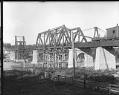
Construction of Great Northern Railway's Ballard Bridge, circa 1913
The Great Northern Railway built a new railway bridge at Ballard in about 1913, during the construction of the Lake Washington Ship Canal. This bridge is still in use in the 2020s, and is known as the Salmon Bay Bridge. The span stays open for canal traffic unless a train is coming.This photo shows the Great Northern Railway bridge during…
ID Number:1983.10.9734.1
Date:Circa 1913
Photograph
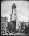
Smith Tower under construction, 1913
The Smith Tower was Seattle's first skyscraper. When it opened in 1914, it was described as the "monster structure that acts as a guiding beacon to vessels in and out of Elliott Bay." For many years, it was the tallest building west of the Mississippi.In this photo, Smith Tower dwarfs an earlier landmark, the Hotel Seattle. The triangular hotel building,…
ID Number:1983.10.9738
Date:1913
Photograph
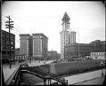
Yesler Way from Fourth Avenue, circa 1913
In 1913, Seattleites looking west from the top of the stairway from Fourth Avenue to Yesler Way would have seen several new buildings. Most eye-catching was the almost-complete Smith Tower, then the tallest building west of the Mississippi River.In this photo, taken around 1913, the new Hotel Seward stands at the base of Smith Tower, and the Frye Hotel stands…
ID Number:1983.10.9741
Date:Circa 1913
Photograph
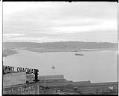
Harbor Island from downtown Seattle, circa 1913
With the expansion of Japanese trade and the start of construction on the Panama Canal, Seattle expected its port business to boom. Beginning around 1905, developers filled in an area of tide flats at the mouth of the Duwamish River for huge new piers and warehouses. This was called Harbor Island.This photo, taken from downtown Seattle, shows Harbor Island in…
ID Number:1983.10.9745
Date:Circa 1913