1580 results for: City of Seattle
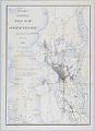
Cartographic material
McKee's Correct Road Map of Seattle and Vicinity, 1894
Redick H. McKee (1864-1949) was born in Louisiana and spent his childhood in Washington, D.C. As a young man, Mr. McKee entered the United States Geological Survey (USGS) and was sent to the Sierra Nevadas and other parts of California. In 1892, McKee established the USGS office in Seattle, and remained a resident of the city until his death.The map…
ID Number:2019.3.12
Date:1894
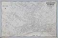
Cartographic material
Business District of Seattle, circa 1940
In 1903 Carl Albert Kroll (1882-1982) immigrated from Germany to the U. S., finding work as a drafting technician at the Moran Brothers shipbuilding company. By 1910, Kroll was the manager at O. P. Anderson Map & Blue Print Company. The following year he acquired both the Anderson Map Company and the Washington Map and Blueprint Company to form the…
ID Number:2019.3.13
Date:Circa 1940
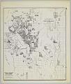
Cartographic material
Anderson's New Guide Map of the City of Seattle & Environs, July 1890
Seattle entrepreneur and amateur photographer O. P. (Oliver Phelps) Anderson (1859-1941) was the son of Alexander Jay Anderson (1832-1903), president of the Washington Territorial University (now University of Washington) from 1877-1882. O. P. trained as a drafting technician and by 1890 had started a civil engineering and map publishing business, O. P. Anderson & Company (later O. P. Anderson Map…
ID Number:2019.3.14
Date:1890
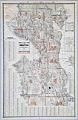
Cartographic material
Seattle, Washington, Postal delivery section map, circa 1950
In 1903 Carl Albert Kroll (1882-1982) immigrated from Germany to the U. S., finding work as a drafting technician at the Moran Brothers shipbuilding company. By 1910 Kroll was the manager at O. P. Anderson Map & Blue Print Company. The following year he acquired both the Anderson Map Company and the Washington Map and Blueprint Company and merged them…
ID Number:2019.3.15
Date:Circa 1950
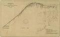
Cartographic material
City of Seattle Harbor Department Map of Central Waterfront District, August 1916
Maritime trade was crucial to the city's economic development, and Seattle continues to be defined and supported by the harbor that has become one of the busiest ports in the U. S. This 1916 map of Elliott Bay depicts wharves and businesses along the waterfront, as well as and water depths (soundings) along piers and in Elliott Bay. Each street,…
ID Number:2019.3.17
Date:1916
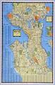
Cartographic material
Seattle, Washington, circa 1938
In 1903 Carl Albert Kroll (1882-1982) immigrated from Germany to the U. S., finding work as a drafting technician at the Moran Brothers shipbuilding company. By 1910 Kroll was the manager at O. P. Anderson Map & Blue Print Company. The following year he acquired both the Anderson Map Company and the Washington Map and Blueprint Company to form the…
ID Number:2019.3.18
Date:Circa 1938
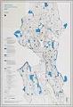
Cartographic material
Open Space Proposed Zoning Map, Seattle, December 1985
Since the beginning of the twentieth century, the City of Seattle showed interest in purposefully growing the city. In 1903 the city contracted the Olmsted Brothers to create a comprehensive Seattle park and boulevard system, and in 1910 hired Virgil G. Bogue to prepare a strategic plan. The Seattle Zoning Commission was created in 1920 to divide the city into…
ID Number:2019.3.19
Date:1985
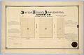
Cartographic material
Boston Heights Supplemental Addition to the City of Seattle, February 25, 1890
Thomas Rock (1846-1908) immigrated to the U. S. from Ireland about 1870. By 1877 he was living in Seattle, and married another Irish immigrant, Mary Ann (Graham) Rock (1853-1932), and started a family. The Rocks owned property in Seattle, probably from a donation land claim granted by the U. S. government, that was platted as the Boston Heights Supplemental Addition…
ID Number:2019.3.20
Date:1890
Cartographic material
Condemnation of Lane Street et al Establishing Grades map, Seattle, July 1916
Starting in 1897 and continuing through 1930, the topography of central Seattle was radically altered by a series of regrades. An estimated 50 tons of earth removed from the city's hills were moved into the tide flats and other low areas, and into Elliott Bay.In June 1916, a bill was passed for the condemnation of property for changing and establishing…
ID Number:2019.3.21
Date:1916
Cartographic material
Yesler Way at Railroad Avenue map, Seattle, 1896
Seattle in the late nineteenth century was a rapidly growing city, aided in no small part by the 1883 connection to the rest of the country by the Northern Pacific Railway Company (NPRR). Additionally, the city's population doubled in 1890 from the previous year to 40,000, boosted by the influx of people who saw opportunity in rebuilding after Seattle's Great…
ID Number:2019.3.22
Date:1896