843 results for: Puget Sound
Photograph
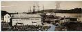
Winslow Harbor, Bainbridge Island, circa 1920
This panorama photo, created when two photographs were cut and glued together, documents the town of Winslow around 1920, naming the H.E. Anderson store and the Winslow Wareshouse. Originally called Madrone, the town changed its name to Winslow in 1903, when the Halls Brothers Shipyard dregded the harbor to move their operations from Port Blakely. Winslow changed its name again…
ID Number:1980.6877.255
Date:Circa 1920
Photograph
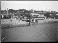
Ballard Beach, Seattle, circa 1910
This photo from around 1910 shows people on Ballard Beach between 64th and 65th Streets. It was taken by Carl Henry Moen, who was born in Seattle in 1892 to Norwegian immigrant parents. His family moved several times as he was growing up, but settled in Ballard when he was nine years old. He helped harvest and sell the produce,…
ID Number:1980.6880.126
Date:Circa 1910
Photograph
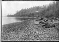
Golden Gardens beach, Seattle, circa 1910
During hot weather, Seattle residents went to nearby swimming beaches. They could travel north by automobile or streetcar to Golden Gardens, on Shilshole Bay. The city purchased the popular beach in 1923, and the park opened several years later. This photo was taken by Carl Henry Moen, who was born in Seattle in 1892 to Norwegian immigrant parents. His family…
ID Number:1980.6880.235
Date:Circa 1910
Photograph
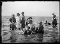
Swimmers at Ballard Beach, Seattle, circa 1913
Carl Henry Moen was born in Seattle in 1892 to Norwegian immigrant parents. His family moved several times as he was growing up, but settled in Ballard when he was nine years old. He helped harvest and sell the produce, milk, and poultry his family raised, and also was a messenger for Western Union, dug clams, and worked for Bemis…
ID Number:1980.6880.307
Date:Circa 1913
Photograph
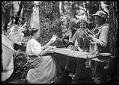
Card game in the woods, Port Madison, circa 1910
Carl Henry Moen was born in Seattle in 1892 to Norwegian immigrant parents. His family moved several times as he was growing up, but settled in Ballard when he was nine years old. He helped harvest and sell the produce, milk, and poultry his family raised, and also was a messenger for Western Union, dug clams, and worked for Bemis…
ID Number:1980.6880.315
Date:Circa 1910
Photograph
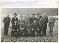
Portrait of First Baptist Church's building committee, Seattle, circa 1908
Seattle First Baptist Church was organized in 1869 by 11 men and women on a lot donated by Elizabeth (Jones) Holgate (1796-1880), a widow who had lived in Seattle since at least 1856. The wooden church was built on the east side of Fourth Avenue, between Cherry Street and James Street. The building was abandoned after 1908 when regrading of…
ID Number:1980.6882.1
Date:Circa 1908
Cartographic material
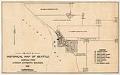
Pettit's Historical Map of Seattle, 1913
This historical map was compiled by Benjamin W. Pettit (1867-1944), a banker who arrived in Seattle from Illinois in 1889 and continued in banking until his retirement from First National Bank in 1941. An amateur photographer and historian, Pettit collected slides and gave presentations on the changes he saw in Seattle since his arrival.This map documents sites and land claims…
ID Number:1980.6923.8
Date:1913

Photograph
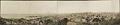
Downtown Seattle from Seventh Avenue and Alder Street, 1914
In 1914 Seattle's population had reached an estimated 304,126. According to the 1914 Polk Seattle City Directory, Seattle boasted the "largest clay products plant on the Pacific Coast; largest shoe factory on Pacific Coast; largest jewelry manufacturing concern on Pacific Coast; largest condensed milk concern in the West; largest dry docks on Pacific Coast; largest fisheries and lumbering interests in…
ID Number:1980.6923.9
Date:1914
Photograph
Seattle from Beacon Hill, circa 1909
Much of downtown Seattle was built on land reclaimed from Elliott Bay and the mouth of the Duwamish River. This four-part panoramic image faces northwest from Beacon Hill and shows the area south of downtown before the Jackson Street regrade (1907-1909) cut through the hill for better access to the Rainier Valley.The King County Courthouse, with its tall cupola, can…
ID Number:1980.6923.10
Date:Circa 1900
Photograph
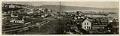
Panorama of Seattle, 1878
This image of Seattle faces southeast across Pike Street, toward Mount Rainier, which is just visible beyond Beacon Hill. According to "Choir's Pioneer Directory," at the time of this photo Seattle had 4,681 residents, 586 buildings, and seven miles of wooden sidewalks. The large square building in the upper left corner of the frame is the Territorial University, built in…
ID Number:1980.6923.38
Date:1878