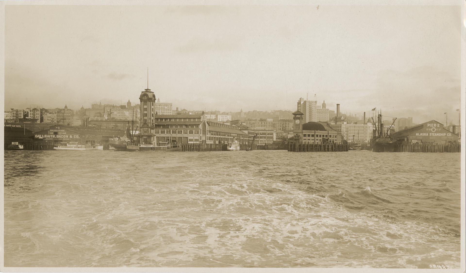
This image, looking east from Elliott Bay, features the working docks of Seattle's waterfront. Prior to the Great Fire in 1889 the piers had generally been constructed perpendicular to the waterfront. They were rebuilt according to the northeast-southwest angle, prescribed by City Engineer Reginald Thomson and Assistant City Engineer George Cotterill in the 1897 tidelands replat, which allowed more ships to dock as well as easier access for trains traveling from Railroad Avenue and loading and unloading at the pier.
At the left of the frame is a sign for the Harper-Colby Routes, a steamboat and ferry company operated by the Kitsap County Transportation Company. The next pier to the south, Pier 3, was home to Galbraith and Bacon's Galbraith Dock from about 1900, and was renamed Pier 54 during World War II. Next the south is the Grand Trunk Pacific (G.T.P.) dock, a shipping pier built in 1910 and dismantled in 1964; the area where the pier stood is now part of the Seattle terminal of the Washington State Ferry system. Next to the south is the Colman Dock, originally built in 1882 at the foot of Columbia Street; the 72-foot clock tower was added in 1908. Although the original pier no longer exists, the terminal, now used by the Washington State Ferry system, is still referred to as Colman Dock or Pier 52. Next to the south is Pier 2 at the foot of Yesler Way, which, like Pier 1, was owned by the Northern Pacific Railway and operated by the Alaska Steamship Company. Piers 1 and 2 were later renamed Piers 51 and 52, then removed in the 1960s.
Photographer's number: 22923
Caption information source: "Now & Then — Seattle Waterfront at Northern Pacific Railroad Piers (Pier 56)," by Paul Dorpat, HistoryLink.org Essay 2578 Caption information source: https://web6.seattle.gov/DPD/HistoricalSite/QueryResult.aspx?ID=1165536054
ID Number: 1980.6923.96
Date: Circa 1910
Physical Description: 1 photographic print : b&w ; 5.25 x 9 in.
Additional Information: Digital copy of this item available thanks to funding from a 2016 Institute for Museum and Library Services grant. Metadata updated as part of a grant from the Institute of Museum and Library Services administered by the Library Services and Technology Act, through the Washington State Library, a division of the Office of the Secretary of State.
Credit: MOHAI, Benjamin Pettit Photograph Collection, 1980.6923.96