Back to Results
1952.986.57.4
View full size image or right-click on image to save
Cartographic material
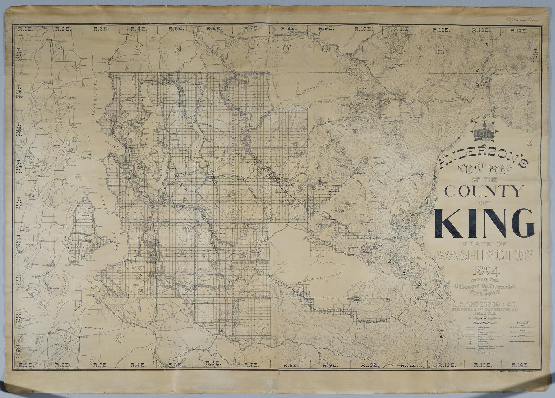
Anderson's New Map of the County of King, State of Washington, 1894
Order an ImageSeattle entrepreneur and amateur photographer O.P. (Oliver Phelps) Anderson (1859-1941) was the son of Alexander Jay Anderson (1832-1903), president of the Washington Territorial University (now University of Washington) from 1877-1882. O.P. trained as a draughtsman and by 1890 had started a civil engineering and map publishing business, O. P. Anderson & Company (later O. P. Anderson Map & Blue Print Company). In 1911, Carl Kroll acquired the Anderson Map Company and the Washington Map and Blueprint Company to become the Kroll Map Company, which is still in operation as of 2019.
This Anderson map of King County identifies important land features and transportation routes, and extends into neighboring Kitsap, Pierce, Kittitas, and Snohomish counties. Military Road is noted in blue pen, and a route along the road from Puyallup to Seattle is hand traced in red.
Printed on map: Anderson's New Map of the County of King, State of Washington, 1894, Compiled from U. S. Surveys - County Records and Private Surveys by O. P. Anderson & Co. Engineers and Draughtsmen, Seattle. Photo-Lith. Britton & Rey, San Francisco, Cal. Entered according to act of Congress in the year 1894 by O. P. Anderson & Co. in the Office of the Librarian of Congress, Washington D. C.
Handwritten in pen on map: Military Road.
This Anderson map of King County identifies important land features and transportation routes, and extends into neighboring Kitsap, Pierce, Kittitas, and Snohomish counties. Military Road is noted in blue pen, and a route along the road from Puyallup to Seattle is hand traced in red.
Printed on map: Anderson's New Map of the County of King, State of Washington, 1894, Compiled from U. S. Surveys - County Records and Private Surveys by O. P. Anderson & Co. Engineers and Draughtsmen, Seattle. Photo-Lith. Britton & Rey, San Francisco, Cal. Entered according to act of Congress in the year 1894 by O. P. Anderson & Co. in the Office of the Librarian of Congress, Washington D. C.
Handwritten in pen on map: Military Road.
ID Number: 1952.986.57.4
Date: 1894
Creator(s):
Anderson Map Co., Creator
Physical Description: 1 map : b&w ; 54.5 x 38.5 in.
Additional Information: Digital copy of this item available thanks to funding from a 2016 Institute for Museum and Library Services grant.
Credit: MOHAI, Sophie Frye Bass Collection, 1952.986.57.4
Copyright: No Known Copyright
Subjects:
Transportation
Other matching results
Naval Training Station construction on University of Washington campus, Seattle, October 1, 1918
Naval Training Station buildings under construction on University of Washington campus, Seattle, October 8, 1918
Naval Training Station barracks on University of Washington campus, Seattle, October 1, 1918

Seattle Girls War Relief Bazaar sign, 1917

Seattle Girls War Relief Bazaar poster by Anita Miller, 1917
Wee Coyle greeting General Leonard Wood on Wenatchee, Seattle, April 9, 1921
U.S. Naval Training Station view, circa 1918
Invitation to USS Nebraska launching on October 7, 1904