Back to Results
1952.986.57.2
View full size image or right-click on image to save
Cartographic material
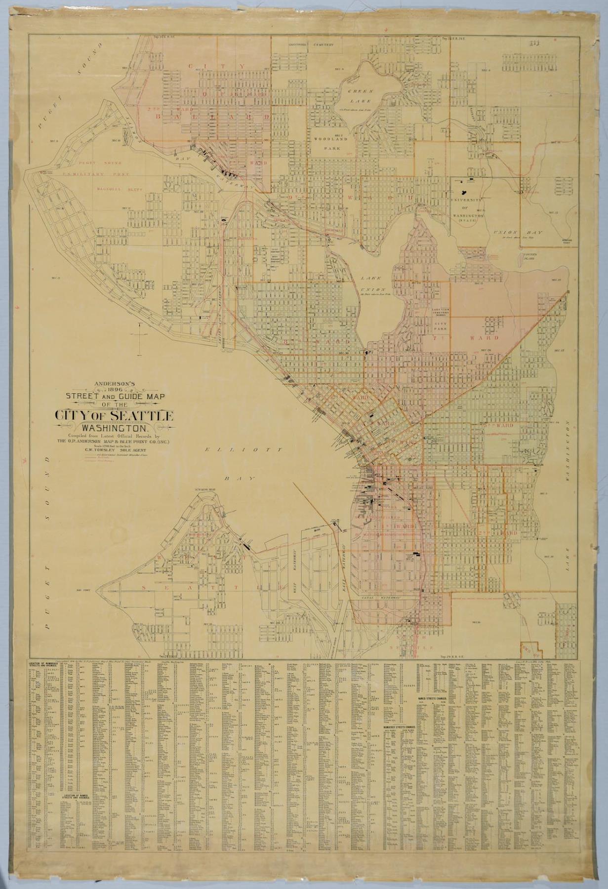
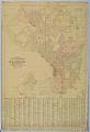
Anderson's 1896 Street and Guide Map of the City of Seattle
Order an ImageSeattle entrepreneur and amateur photographer O.P. (Oliver Phelps) Anderson (1859-1941) was the son of Alexander Jay Anderson (1832-1903), president of the Washington Territorial University (now University of Washington) from 1877-1882. O.P. trained as a draughtsman and by 1890 had started a civil engineering and map publishing business, O. P. Anderson & Company (later O. P. Anderson Map & Blue Print Company). In 1911, Carl Kroll acquired the Anderson Map Company and the Washington Map and Blueprint Company to become the Kroll Map Company, which is still in operation as of 2019.
This street map of the city includes a key with old and new street names, railroad and street railway routes, outlines of Seattle's nine wards with indication of the lands being filled in along the Duwamish River tidelands, and outlines of West Seattle, South Seattle, Ballard, and Columbia.
Text on map: Anderson's 1896 Street and Guide Map of the City of Seattle, Washington. Compiled from the Latest Official Records by the O. P. Anderson Map & Blue Print Co. (Inc.), Scale 1200 feet to the inch, C. W. Towsley, Sole Agent. Copyright 1896 by the O. P. Anderson Map & Blue Print Co. (Inc.), Occidental Block, Seattle, Washington.
Caption source information: "About Kroll Map Company," Kroll Map Company, https://www.krollmapcompany.com/who-we-are/.
This street map of the city includes a key with old and new street names, railroad and street railway routes, outlines of Seattle's nine wards with indication of the lands being filled in along the Duwamish River tidelands, and outlines of West Seattle, South Seattle, Ballard, and Columbia.
Text on map: Anderson's 1896 Street and Guide Map of the City of Seattle, Washington. Compiled from the Latest Official Records by the O. P. Anderson Map & Blue Print Co. (Inc.), Scale 1200 feet to the inch, C. W. Towsley, Sole Agent. Copyright 1896 by the O. P. Anderson Map & Blue Print Co. (Inc.), Occidental Block, Seattle, Washington.
Caption source information: "About Kroll Map Company," Kroll Map Company, https://www.krollmapcompany.com/who-we-are/.
ID Number: 1952.986.57.2
Date: 1896
Creator(s):
Anderson Map Co., Creator
Physical Description: 1 map : color ; 37 x 55 in.
Additional Information: Digital copy of this item available thanks to funding from a 2016 Institute for Museum and Library Services grant.
Credit: MOHAI, Sophie Frye Bass Collection, 1952.986.57.2
Copyright: No Known Copyright
Other matching results
Home of Harry Whitney and Olive Treat on West Highland Drive, Seattle, circa 1906
View west on Boyer Avenue, Seattle, December 15, 1911
View west on Boyer Avenue, Seattle, March 15, 1913
View east on Boyer Avenue, Seattle, March 15, 1913
Anderson's 1896 Street and Guide Map of the City of Seattle
Views of East Newton Street, Seattle, 1911 and 1912
Favorite Recipes of the North Queen Anne Guild of the Children's Orthopedic Hospital, 1926
Horace C. Henry home, Seattle, circa 1920
Complete Map of the City of Ballard, Wash. and Vicinity, November 15, 1904